Little Hatfield

Coordinates: 53°52′20″N 0°12′58″W / 53.872273°N 0.215976°W
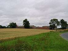
Little Hatfield is a small hamlet in the East Riding of Yorkshire, England, in an area known as Holderness. It is situated approximately 3 miles (5 km) south-west of Hornsea town centre, and less than 1 mile (1.6 km) west of Great Hatfield.
Little Hatfield
In 1823 Little Hatfield was in the civil parish of Sigglesthorne, and in the Wapentake and Liberty of Holderness. Population at the time was 25, which included a farmer.[1]
The village was a civil parish until 1935, when it was merged with Goxhill and Great Hatfield to form the parish of Hatfield.[2]
Little Hatfield was served from 1864 to 1964 by Sigglesthorne railway station on the Hull and Hornsea Railway.[3]
References
- ↑ Baines, Edward (1823): History, Directory and Gazetteer of the County of York, p. 214
- ↑ "Little Hatfield Tn/CP Yorkshire through time – Administrative history of Parish-level unit: hierarchies, boundaries". A Vision of Britain through Time. University of Portsmouth & others. 2008. Retrieved 19 November 2008.
- ↑ Butt, R. V. J. (1995). The Directory of Railway Stations: details every public and private passenger station, halt, platform and stopping place, past and present (1st ed.). Sparkford: Patrick Stephens Ltd. ISBN 1-8526-0508-1. OCLC 60251199.
- Gazetteer — A–Z of Towns Villages and Hamlets. East Riding of Yorkshire Council. 2006. p. 7.
External links
 Media related to Little Hatfield at Wikimedia Commons
- Little Hatfield in the Domesday Book
This article is issued from Wikipedia - version of the 12/4/2014. The text is available under the Creative Commons Attribution/Share Alike but additional terms may apply for the media files.