Long Island (Antarctica)
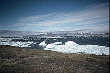
View of James Ross Island from Long Island
Long Island (63°46′S 58°12′W / 63.767°S 58.200°WCoordinates: 63°46′S 58°12′W / 63.767°S 58.200°W) is an island 3 nautical miles (6 km) long, in a northeast–southwest direction, and 0.5 nautical miles (1 km) wide, lying opposite the mouth of Russell East Glacier and 2 nautical miles (4 km) south of Trinity Peninsula, Antarctica, in Prince Gustav Channel. It was discovered and named by the Falkland Islands Dependencies Survey in 1945; the name is descriptive.[1]
See also
References
- ↑ "Long Island". Geographic Names Information System. United States Geological Survey. Retrieved 2013-06-30.
![]() This article incorporates public domain material from the United States Geological Survey document "Long Island" (content from the Geographic Names Information System).
This article incorporates public domain material from the United States Geological Survey document "Long Island" (content from the Geographic Names Information System).
This article is issued from Wikipedia - version of the 11/21/2015. The text is available under the Creative Commons Attribution/Share Alike but additional terms may apply for the media files.