Louisiana Highway 500
| ||||
|---|---|---|---|---|
 | ||||
| Route information | ||||
| Maintained by Louisiana DOTD | ||||
| Length: | 24.6 mi[1] (39.6 km) | |||
| Existed: | 1955 – present | |||
| Major junctions | ||||
| West end: |
| |||
|
| ||||
| East end: |
| |||
| Location | ||||
| Parishes: | Grant, Winn, La Salle | |||
| Highway system | ||||
| ||||
.svg.png)
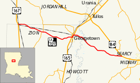
Louisiana Highway 500 (LA 500) is a state highway in Louisiana. It spans 24.6 miles (39.6 km), serving Grant, Winn, and La Salle parishes.
Route description
LA 500 begins near the parish line between Grant and Winn parishes at U.S. Route 167 (US 167). Though the intersection with US 167 is fully in Grant Parish, LA 500 travels east along the parish line for about 1.3 miles (2.1 km). The highway travels east through the Kisatchie National Forest, joining LA 472 for a short distance. After splitting from LA 472, LA 500 enters the small town of Georgetown, meeting US 165. It crosses US 165 and turns north at an intersection with LA 502, soon meeting LA 1230.[1]
LA 500 then turns to the east, while a short signed section travels to the north to meet US 165. LA 500 then enters La Salle Parish, ending after a short distance at an intersection with US 84.[1]
LA 500 is an undivided, two-lane road for its entire route. Before the 1955 Louisiana Highway renumbering, LA 500 was known as State Route 108. A portion of LA 500 between its junction with LA 502 and LA 1230 is an original piece of US 165. Therefore, LA 500 was also signed as State Route 14, and later State Route 2115.
Junction list
| Parish | Location | mi[1] | km | Destinations | Notes |
|---|---|---|---|---|---|
| Grant | Packton | 0.0 | 0.0 | ||
| Zion | 5.4 | 8.7 | Western end of LA 472 concurrency | ||
| 5.6 | 9.0 | Eastern end of LA 472 concurrency | |||
| Georgetown | 12.1 | 19.5 | |||
| 12.4 | 20.0 | Northern terminus of LA 502 | |||
| 12.8 | 20.6 | Eastern terminus of LA 1230 | |||
| 12.9 | 20.8 | ||||
| La Salle | Searcy | 24.6 | 39.6 | ||
| 1.000 mi = 1.609 km; 1.000 km = 0.621 mi | |||||
See also
 Louisiana portal
 U.S. Roads portal
References
- 1 2 3 4 Google (February 16, 2015). "Louisiana Highway 500" (Map). Google Maps. Google. Retrieved February 16, 2015.