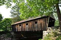
Lovejoy Bridge
|
Lovejoy Bridge | |
 | |
  | |
| Location | Over Ellis River, South Andover, Maine |
|---|---|
| Coordinates | 44°35′37″N 70°44′2″W / 44.59361°N 70.73389°WCoordinates: 44°35′37″N 70°44′2″W / 44.59361°N 70.73389°W |
| Area | 0.3 acres (0.12 ha) |
| Built | 1868 |
| Architectural style | Paddleford truss |
| NRHP Reference # | 70000057[1] |
| Added to NRHP | February 16, 1970 |
The Lovejoy Bridge is a historic covered bridge in South Andover, Maine. It is a Paddleford truss bridge, which carries Covered Bridge Road over the Ellis River, about 9 miles (14 km) north of US Route 2. Built in 1868, it is one of a small number of 19th-century covered bridges remaining in the state, and it is the state's shortest covered bridge. It was listed on the National Register of Historic Places in 1970.[1]
Description
The Ellis River cuts a meandering course through the town of Andover, joining the Androscoggin River at Rumford Point. There has probably been a bridge at this site in southern Andover since the early 19th century, as the river course narrows sufficiently, and provides a crossing point for people traveling between Rumford Point and the main village of Andover, which is located further north. This bridge was built in 1868, but it is known that a small village already existed nearby, suggesting the existence of a previous bridge.[2]
The bridge is 70 feet (21 m) long and 20 feet (6.1 m) wide, with a roadway width of 17 feet (5.2 m) and an internal clearance of 14 feet (4.3 m). It rests on abutments built out of large granite blocks. The bridge has a gabled roof, giving it a total height of 22 feet (6.7 m). Its sides are sheathed in vertical boards, and the gable ends have been trimmed.[2] The bridge was reinforced in 1984 to support local traffic.[3]
See also
| Wikimedia Commons has media related to Lovejoy Covered Bridge. |
- National Register of Historic Places listings in Oxford County, Maine
- List of bridges on the National Register of Historic Places in Maine
- List of Maine covered bridges
References
- 1 2 National Park Service (2010-07-09). "National Register Information System". National Register of Historic Places. National Park Service.
- 1 2 "NRHP nomination for Lovejoy Bridge" (PDF). National Park Service. Retrieved 2014-11-28.
- ↑ "Lovejoy Bridge". Maine Department of Transportation. Retrieved 2014-11-28.