Mahottari District
| Mahottari महोत्तरी जिल्ला | |
|---|---|
| District | |
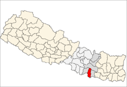
 Location of Mahottari | |
| Country | Nepal |
| Region | Central (Madhya Anchal) |
| Zone | Janakpur |
| Headquarters | Jaleshwar |
| Area | |
| • Total | 1,002 km2 (387 sq mi) |
| Population (2011) | |
| • Total | 627,580 |
| • Density | 630/km2 (1,600/sq mi) |
| Time zone | NPT (UTC+5:45) |
| Main language(s) | maithili (80%), nepali (7.2%), other (5.5%) |
Mahottari District (Nepali: महोत्तरी जिल्ला,![]() Listen ), a part of Province No. 2, is one of the seventy-five districts of Nepal. The district, with Jaleshwar as its district headquarters, covers an area of 1,002 km² and had a population of 553,481 in 2001 and 627,580 in 2011.[1]
Listen ), a part of Province No. 2, is one of the seventy-five districts of Nepal. The district, with Jaleshwar as its district headquarters, covers an area of 1,002 km² and had a population of 553,481 in 2001 and 627,580 in 2011.[1]
Its headquarters is located in Jaleshwar, a neighbouring town of the historical city of Janakpur. The name Jaleshwar means the 'God in Water'. One can find a famous temple of Lord Shiva in Water there. Jaleshwar lies at a few kilometres distance from the Nepal-India border and has a majority of Maithili people. In janakpur zone there are two districts ; mahottari and dhanusha and both are in a distance of 1 hour.
Geography and Climate
| Climate Zone[2] | Elevation Range | % of Area |
|---|---|---|
| Lower Tropical | below 300 meters (1,000 ft) | 85.0% |
| Upper Tropical | 300 to 1,000 meters 1,000 to 3,300 ft. |
15.0% |
Village Development Committees (VDCs) and Municipalities

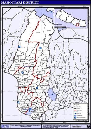
The 2011 National Population and Housing Census by the government of Nepal identifies 77 municipalities and village development committees (VDC) within the Mahottari District.[3]
- Anakar
- Aurahi
- Bagada
- Bagiya Banchauri
- Bairgiya Laksminiya
- Balawa
- Banauli Donauli
- Banauta
- Bardibas Municipality
- Basabitti
- Bathnaha
- Belgachhi
- Bhangaha
- Bharatpur
- Bhatauliya
- Bijayalpura
- Bhramarpura
- Damhi Marai
- Dhamaura
- Dharmapur
- Dhirapur
- Ekadarabela
- Ekarahiya
- Etaharwakatti
- Gaidha Bhetpur
- Gauribas
- Gaushala Municipality
- Gonarpura
- Halkhori
- Hariharpur Harinagari
- Hathilet
- Hatisarwa
- Jaleshwar Municipality
- Khairbanni
- Khaya Mara
- Khopi
- Khuttapipradhi
- Kisan Nagar
- Kolhusa Bagaiya
- Laksminiya
- Loharpatti
- Mahadaiyatapanpur
- Mahottari
- Maisthan
- Majhora Bishnupur
- Manara
- Matihani
- Meghanath Gorhanna
- Nainhi
- Nigaul
- Padaul
- Parsa Pateli
- Parsadewadh
- Pashupatinagar
- Phulahatta Parikauli
- Phulakaha
- Pigauna
- Pipra
- Pokharibhinda Samgrampur
- Raghunathpur
- Ramgopalpur
- Ramnagar
- Ratauli
- Sahasaula
- Sahorawa
- Samdha
- Sarpallo
- Shamsi
- Sripur
- Simardahi
- Singyahi
- Sisawakataiya
- Sonama
- sonamai bhoil
- Sonaum
- Suga Bhawani
- Sundarpur
References
- ↑ Household and population by districts, Central Bureau of Statistics (CBS) Nepal
- ↑ The Map of Potential Vegetation of Nepal - a forestry/agroecological/biodiversity classification system (PDF), . Forest & Landscape Development and Environment Series 2-2005 and CFC-TIS Document Series No.110., 2005, ISBN 87-7903-210-9, retrieved Nov 22, 2013 horizontal tab character in
|series=at position 91 (help) - ↑ National Planning Commission Secretariat (November 2012). "National Population and Housing Census 2011" (PDF). Central Bureau of Statistics. Government of Nepal. pp. 27–28. Retrieved 3 May 2015.
- "Districts of Nepal". Statoids.
Coordinates: 26°38′0″N 85°48′0″E / 26.63333°N 85.80000°E
| Wikimedia Commons has media related to Mahottari District. |
