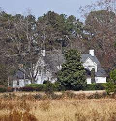
Manship Farmstead
|
Manship Farmstead | |
|
Manship Farmstead, December 2012 | |
  | |
| Nearest city | 2601 Manship Rd., near Tatum, South Carolina |
|---|---|
| Coordinates | 34°39′31″N 79°35′46″W / 34.65861°N 79.59611°WCoordinates: 34°39′31″N 79°35′46″W / 34.65861°N 79.59611°W |
| Area | 325 acres (132 ha) |
| Built | 1906 |
| NRHP Reference # | 97000540[1] |
| Added to NRHP | June 4, 1997 |
Manship Farmstead is a historic farmstead and national historic district located near Tatum, Marlboro County, South Carolina. The district encompasses seven contributing buildings, one contributing site, and one contributing object in an early 20th century agricultural complex. They consist of the main house (1906), outbuildings (commissary/carriage house, warehouse, two barns, tobacco barn, tenant house, and well house), a farm bell, the Manship family cemetery, and associated historic rural landscape.[2][3]
It was listed on the National Register of Historic Places in 1997.[1]
References
- 1 2 National Park Service (2010-07-09). "National Register Information System". National Register of Historic Places. National Park Service.
- ↑ Stephen Smith (March 1996). "Manship Farmstead" (pdf). National Register of Historic Places - Nomination and Inventory. Retrieved 24 July 2012.
- ↑ "Manship Farmstead, Marlboro County (2601 Manship Rd., Tatum vicinity)". National Register Properties in South Carolina. South Carolina Department of Archives and History. Retrieved 24 July 2012.
This article is issued from Wikipedia - version of the 11/30/2016. The text is available under the Creative Commons Attribution/Share Alike but additional terms may apply for the media files.


