Massachusetts Route 225
| ||||
|---|---|---|---|---|
|
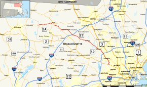
Map of eastern Massachusetts with Route 225 highlighted in red | ||||
| Route information | ||||
| Length: | 23.8549 mi[1] (38.3907 km) | |||
| Existed: | 1957 (renumbered from Route 25) – present | |||
| Major junctions | ||||
| West end: |
| |||
| East end: |
| |||
| Location | ||||
| Counties: | Worcester, Middlesex | |||
| Highway system | ||||
| ||||

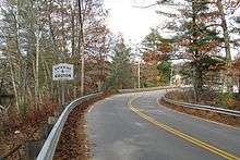
Eastbound entering Groton
Route 225 is a northwest-southeast state highway in Massachusetts, which is signed as an east–west route. It was formerly known as Route 25 prior to the construction of Interstate 495 south of Raynham in 1957, which was given the Route 25 designation. The stretch of highway between the Bourne Bridge in Bourne, and exit 1 of Interstate 495 (its junction with Interstate 195) in Wareham still bears the Route 25 designation, while the rest of Route 25 has been re-designated as Interstate 495 as of 1987.
Major intersections
| County | Location | mi | km | Destinations | Notes |
|---|---|---|---|---|---|
| Worcester | Lunenburg | 0.0000 | 0.0000 | Western terminus | |
| Middlesex | Groton | 4.9 | 7.9 | Southern terminus of concurrency with Route 111 | |
| 5.4 | 8.7 | Northern terminus of concurrency with Route 111 | |||
| 5.6 | 9.0 | Western terminus of concurrency with Route 119 | |||
| 6.0 | 9.7 | Western terminus of Route 40 | |||
| 9.4 | 15.1 | Eastern terminus of concurrency with Route 119 | |||
| Westford | 13.8 | 22.2 | No access between Route 225 and I-495 | ||
| 13.9 | 22.4 | Western terminus of concurrency with Route 110 | |||
| 14.2 | 22.9 | Eastern terminus of concurrency with Route 110 | |||
| 17.0 | 27.4 | ||||
| Bedford | 23.8549 | 38.3907 | Northern terminus of concurrency with Route 4 | ||
| 24.0 | 38.6 | Western terminus of concurrency with Route 62 | |||
| 24.8 | 39.9 | Eastern terminus of concurrency with Route 62 | |||
| Lexington | 26.6 | 42.8 | Exit 31A and 31B on I-95 / Route 128 | ||
| 29.6 | 47.6 | Western terminus of concurrency with Route 2A | |||
| 29.7 | 47.8 | Eastern terminus of concurrency with Route 2A | |||
| 31.1 | 50.1 | Eastern terminus Southern terminus of Route 4 and concurrency with Route 4 Exit 56 on Route 2 | |||
1.000 mi = 1.609 km; 1.000 km = 0.621 mi
| |||||
References
- "Massachusetts Atlas and Gazetteer." Yarmouth, Maine: DeLorme. First Edition, 1998.
- "The Roads of Massachusetts" www.maroads.com
External links
| Wikimedia Commons has media related to Massachusetts Route 225. |
This article is issued from Wikipedia - version of the 8/25/2014. The text is available under the Creative Commons Attribution/Share Alike but additional terms may apply for the media files.