Massachusetts Route 78
| ||||
|---|---|---|---|---|
 | ||||
| Route information | ||||
| Length: | 9.73 mi[1] (15.66 km) | |||
| Major junctions | ||||
| South end: |
| |||
| North end: |
| |||
| Location | ||||
| Counties: | Franklin | |||
| Highway system | ||||
| ||||
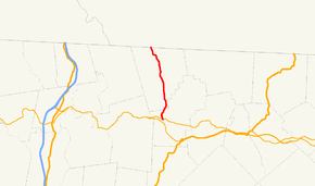
Route 78 is a short south–north highway in northeastern Franklin County, Massachusetts.
Route description
Route 78 begins at Route 2A in Orange, just north of the Springfield Terminal railroad tracks and the Millers River. After 1.4 miles (2.3 km), the route enters the town of Warwick. The route passes by several portions of Warwick State Forest and through the town center, before passing Mount Grace and entering Winchester, New Hampshire as New Hampshire Route 78. The route does not intersect any other state routes.
Route 78 at its northern terminus looking southbound.
Major Intersections
The entire route is in Franklin County.
| Location | mi | km | Destinations | Notes | |
|---|---|---|---|---|---|
| Orange | 0.0 | 0.0 | South end of Route 78 | ||
| Warwick | 6.3 | 10.1 | Athol Road – Athol | ||
| 9.7 | 15.6 | Continuation into New Hampshire | |||
| 1.000 mi = 1.609 km; 1.000 km = 0.621 mi | |||||
References
- ↑ "Massachusetts Route Log Applicaton". Massachusetts Department of Transportation. Retrieved September 24, 2016.
This article is issued from Wikipedia - version of the 9/24/2016. The text is available under the Creative Commons Attribution/Share Alike but additional terms may apply for the media files.
