Medemblik
| Medemblik | |||
|---|---|---|---|
| Municipality | |||
|
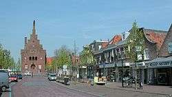
Medemblik city centre | |||
| |||
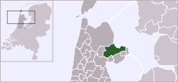
 Location in North Holland | |||
| Coordinates: 52°41′N 5°2′E / 52.683°N 5.033°ECoordinates: 52°41′N 5°2′E / 52.683°N 5.033°E | |||
| Country | Netherlands | ||
| Province | North Holland | ||
| Government[1] | |||
| • Body | Municipal council | ||
| • Mayor | Frank Streng (VVD) | ||
| Area[2] | |||
| • Total | 257.56 km2 (99.44 sq mi) | ||
| • Land | 121.81 km2 (47.03 sq mi) | ||
| • Water | 135.75 km2 (52.41 sq mi) | ||
| Elevation[3] | 0 m (0 ft) | ||
| Population (May 2014)[4] | |||
| • Total | 43,391 | ||
| • Density | 356/km2 (920/sq mi) | ||
| Time zone | CET (UTC+1) | ||
| • Summer (DST) | CEST (UTC+2) | ||
| Postcode | Parts of 1600 range | ||
| Area code | 0227–0229 | ||
| Website |
www | ||

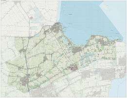
Medemblik ([ˈmeːdəmblɪk]) is a municipality and a town in the Netherlands, in the province of North Holland and the region of West-Frisia.[5] It lies immediately south of the polder and former municipality of Wieringermeer.
History

Medemblik was a prosperous trading town, when in 1282, Floris V, Count of Holland, successfully invaded West Friesland. He built several fortresses to control the region, one of which was Kasteel Radboud in Medemblik, and awarded Medemblik city rights in 1289. After Floris V had been murdered in 1296, the local Frisian besieged the castle, but in 1297 an army from Holland thwarted their efforts to starve out the inhabitants, which included Medemblik citizens.[6]
Several more attacks took place in the following centuries. The most notorious of these happened in June 1517, when Medemblik was attacked from mainland Frisia by about 4000 pirates known as the Arumer Zwarte Hoop, led by Pier Gerlofs Donia and Wijard Jelckama. Many citizens fled to the castle, which the pirates unsuccessfully besieged. Eventually, they took out their fury on the town, which burned to the ground. After this the band continued their marauding path on land throughout present day North Holland.[7]
Medemblik obtained town walls in 1572, so that the castle lost its roll as a refuge for the citizens, which led to its partially dismantling in 1578. Over the centuries the castle fell into decay, but in 1889 it became property of the crown and was restored to be used as a courthouse, which function it served until 1934. Anticipating the German invasion, the Rijksmuseum in September 1939 chose the castle as the initial hiding place of Rembrandt's Night Watch.[6]
On 1 January 2007, Medemblik merged with the municipalities of Noorder-Koggenland and Wognum, yet retained its own name in the surviving municipality, even though it was the smallest of the three in population. Again on 1 January 2011 Medemblik merged with Andijk and Wervershoof into the municipality Medemblik.
The new city hall is the former office building of the DSB Bank in Wognum.
Tourism
Medemblik is best known in Europe for its sailing events. Medemblik further has a picturesque small innercity with many houses from the 17th and 18th century, two big churches, an old orphanage, a town hall and, of course, castle Radboud, which is just at the border of the innercity.
Local government
The municipal council of Medemblik consists of 27 seats, which are divided as follows:
- VVD - 8 seats
- CDA - 6 seats
- PvdA - 3 seats
- Gemeentebelangen - 3 seats
- Progressief West Friesland - 2 seats
- ChristenUnie - 1 seat
- D66 - 1 seat
- Andijker Belang - 1 seat
- PW2010 - 1 seat
- Onafhankelijke Westfriese Partij - 1 seat
Notable residents
- Jan Albertsz Rotius (1624) Painter
- Willem Vogelsang (1956)
Gallery
 Medemblik, church: de Sint-Martinuskerk
- Medemblik, near spoortram station
 Medemblik, church: Grote of Sint Bonifaciuskerk
- Medemblik Castle on a drawing by Johannes Blaeu
References
- ↑ "Frank Streng" (in Dutch). Gemeente Medemblik. Retrieved 6 March 2014.
- ↑ "Kerncijfers wijken en buurten" [Key figures for neighbourhoods]. CBS Statline (in Dutch). CBS. 2 July 2013. Retrieved 12 March 2014.
- ↑ "Postcodetool for 1687CD". Actueel Hoogtebestand Nederland (in Dutch). Het Waterschapshuis. Retrieved 6 March 2014.
- ↑ "Bevolkingsontwikkeling; regio per maand" [Population growth; regions per month]. CBS Statline (in Dutch). CBS. 26 June 2014. Retrieved 24 July 2014.
- ↑ "Gemeente Medemblik". Retrieved 4 August 2010.
- 1 2 Ben Dijkhuis The Castle at Medemblik
- ↑ Ben Dijkhuis Grote Pier en de Zwarte Hoop in 1517 (in Dutch)
External links
 Media related to Medemblik at Wikimedia Commons
 "Medemblik". Encyclopædia Britannica. 18 (11th ed.). 1911.
- Official website
 |
Hollands Kroon | IJsselmeer |  | |
| Opmeer | |
Enkhuizen | ||
| ||||
| | ||||
| Koggenland | Hoorn, Drechterland, Stede Broec |


