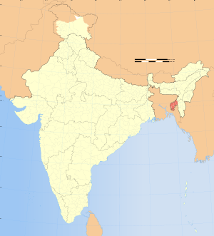
Melaghar
| Melaghar মেলাঘর | |
|---|---|
| Town | |
 Melaghar | |
| Coordinates: IN 23°29′N 91°20′E / 23.49°N 91.33°ECoordinates: IN 23°29′N 91°20′E / 23.49°N 91.33°E | |
| Country |
|
| Region | North-Eastern |
| State | Tripura |
| District | Sipahijala district |
| Subdivision | Sonamura |
| Government | |
| • Type | Municipal Council |
| • Body | MMC |
| Elevation | 11 m (36 ft) |
| Population (2015) | |
| • Total | 19,714 |
| Languages | |
| • Official | Bengali, English |
| • Max. Spoken Language | Bengali, Kokborok, Hindi |
| Time zone | IST (UTC+5:30) |
| PIN | 799115 |
| Vehicle registration | TR 01 XX YYYY, TR 03 XX YYYY, TR 07 XX YYYY |
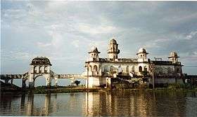
Melaghar(Bengali: মেলাঘর) is a Municipal Town(MMC) in Sipahijala district in the Indian state of Tripura, situated about 50 km (approx.) from capital Agartala. It is a neighbour town to Sonamura and only 10 km away from Bangladesh border. It contains a Hospital, Police station, 2 Major Schools, few Primary schools, a Motorstand, Petrol-Pump, Cell Towers and a Town Hall. The famous Water Palace Neermahal is situated in the middle of Rudrasagar Lake in this town.
Geography and Climate
Melaghar is situated in a low elevation of 15 meters. Melaghar is blessed with a peaceful climate most of the year. However, summer time can be excessively hot, dry, humid and interspersed with rains and thunderstorms. Winter generally starts towards the end of November and lasts until February, where the temperatures can reach very low conditions. The monsoon season in Melaghar starts in April during the Bengali month of Boishakh. During the monsoon season, Melaghar is inundated frequently due to excessive rainfall and flooding by the local rivers as by the 1993 and 2007 Tripura Floods to be remembered.
| Climate data for Melaghar | |||||||||||||
|---|---|---|---|---|---|---|---|---|---|---|---|---|---|
| Month | Jan | Feb | Mar | Apr | May | Jun | Jul | Aug | Sep | Oct | Nov | Dec | Year |
| Record high °C (°F) | 30 (86) |
33 (91) |
38 (100) |
38 (100) |
38 (100) |
40 (104) |
39 (102) |
38 (100) |
37 (99) |
35 (95) |
32 (90) |
28 (82) |
40 (104) |
| Average high °C (°F) | 23 (73) |
25 (77) |
30 (86) |
31 (88) |
34 (93) |
35 (95) |
33 (91) |
32 (90) |
31 (88) |
30 (86) |
27 (81) |
24 (75) |
30 (86) |
| Average low °C (°F) | 10 (50) |
12 (54) |
15 (59) |
20 (68) |
22 (72) |
25 (77) |
25 (77) |
25 (77) |
24 (75) |
21 (70) |
16 (61) |
11 (52) |
19 (66) |
| Record low °C (°F) | 2 (36) |
6 (43) |
6 (43) |
11 (52) |
16 (61) |
19 (66) |
20 (68) |
21 (70) |
20 (68) |
15 (59) |
10 (50) |
5 (41) |
2 (36) |
| Average precipitation mm (inches) | 11.4 (0.449) |
12.8 (0.504) |
57.7 (2.272) |
142.3 (5.602) |
248.0 (9.764) |
350.1 (13.783) |
353.6 (13.921) |
269.9 (10.626) |
166.2 (6.543) |
79.2 (3.118) |
19.4 (0.764) |
5.1 (0.201) |
1,717.7 (67.626) |
| Source: wunderground.com[1] | |||||||||||||
Demographics
Melaghar has a total population of 19,714 (as of 2015). It is one of the major town in Tripura and also 2nd in Sipahijala district after Bishalgarh. Males constitute around 50.4% of the population and females 49.6%.
Melaghar has an average literacy rate of 90.12%, higher than the national average of 74.04%. Male literacy is 93.41% and female literacy is 86.83%.[3]
Sex ratio of Melaghar is 984 females per 1000 males. A total of 11% of the population are under 6 years of age. Whilst the majority speak Bengali, Melaghar is also home to Bengali speaking tribes and also Hindi, as some of them are Bihari.
Location
Melaghar is located in Sonamura Subdivision, on the bank of Gomati river. It's became a Municipal Town (from RD Block) in 2014. Coordinates are 23.49°N 91.33°E.
Politics
Melaghar assembly constituency is a part of Tripura West (Lok Sabha constituency).[4]
Education
Important High Schools
- Melaghar Class XII School
- Melaghar Girls Class XII School
- Melaghar Thakurpara High School
- KalamKhet High School
- Rangamura Upper High School
- Poangbari High School
- Khas Chowmuhuni High School
- Khamarbari High School
- Bogabasa High School
- Chandanmura High School
- Garurban High School
- Some Kindergarten schools and primary schools are spread over in all Melaghar.
- More on a great project for education is planning by some genius boys from Melaghar Class Xii School Alumni group led by Shamim Akter(Software Engineer) and Souman Roy to enhance the future scope for technical students & aspirant kids**
Colleges
The nearest college is Kabi Nazrul Mahavidyalaya located in Sonamura area, distance about 6.5 km from Melaghar.
Sports
Cricket is the major and most played game in Melaghar. There is so many small fields here and there, but the only one big field is located at the behind of Melaghar Class XII School, locally known as Kajal Maidan. Many times Domestic Matches have been played there. Thus the field is remaking as Stadium and will surely play a Ranji Trophy match.
Transport
The main Transport system of Melaghar is Road Transport System. One part of the National Highway 44 is gone through this town that got divided into two roads in Bishalgarh. The part started from Bishalgarh and end at Sonamura motorstand. As this is the main road of Melaghar, also known as Melaghar-Sonamura main road (SH-6). There is a small motorstand that is developing day by day. Hundreds peoples are travels to others place and come daily from here. Melaghar is well connected to capital Agartala (via Nalchar, Bishalgarh, Bishramganj, Amtali) and one of the major city Udaipur,Tripura (via Kakrabon and Matarbari). The new Bus Service Sonamura to Agartala is also available here. Local Auto-Rickshaws are available here as some goes to local destinations. The nearest airport is Agartala Airport, that is about 60 km from the main town.
Local sights and attractions
Durga Puja Festival
One of the best times to visit Melaghar is during the famous Durga Puja when the streets come alive and people from the entire town flock to the town centre to visit the many statues of goddess Durga scattered around the town. Durga Puja is an annual Hindu festival that celebrates worship of the Hindu goddess Durga. It refers to all the six days observed as Mahalaya, Shashthi, Saptami, Ashtami, Navami and Bijoya Dashami.
Melaghar is in good position in term of MAA DURGA PUJA for its pandals in all the state.
Kali Puja Festival
One of the main festivals is the Kali Puja which occurs between October and November and is where the children, adults and the elderly enjoy famously. Melaghar also known for its bright lights during this Puja where the entire town is lit up beautifully.
All the people of Tripura knows that in term of MAA KALI PUJA, Melaghar is one of the best city for its big pandals & crowd.
Ratha Yatra
Melaghar RathaYatra is one of the oldest and biggest Mela(Fair) of Tripura. Every year in July (Bengali: আষাঢ়) it helds at Jagannath Bari field. Thousands of people come to increase the crowd and popularity.
- Melaghar Rath is the 2nd tallest in whole India after Mahesh Rath.
Shops and markets
- Anandabazar is a shopping market in Melaghar. Just re-opened in 2014 by CM Manik Sarkar. It has all types of shops likely Grocery Stores, Book Shops, Stationery and others Varieties.
- The Infotech System and Style House are two new opened Shopping Shop here.
- The famous book shops in this town are Sikshaniketan, The Sikshaniketan etc.
- One of the famous sweet shops of Melaghar is Matri Bhandar(মাতৃভান্ডার) that everyone knows.
- By the way, a famous Khadims Shoe Centre opened a shop near Hospital Road in Melaghar.
- There are a lot of fashion shops, that peoples formally known as Textiles in Melaghar.
- Another two Shopping Market's construction is going on. One is near Motorstand, another is near Netaji Choumuhuni.
Tourist spots and other attractions
Neermahal
Neermahal is the main spot of Melaghar. It is the 2nd beautiful Water Palace in this type after Jal Mahal in Rajasthan and only one in Eastern India. The palace was built by Maharaja (King) Bir Bikram Kishore Debbarman (1926-1930). Its actually a Palace in the middle of Rudrasagar Lake. It is located about 2 km from the Main Market. There are also Boat Rides to travel the main Palace from Rajghat Ferryghat. Sagarmahal is a Lodge Hotel for that tourists, who wish to spend a night here. Every year Hundred of people come here for picnic in the winter time. Also so many foreigner birds come in this lake at the winter season. There is great view of this Palace in every night.

Other attractions
- Veeramma Kali Mandir
- The other attractions are Joyramthakur Ashram, Jagannathbari, Melaghar Kalibari (also famous for Pagli Masi ).
- The Re-made new Town Hall is also of the attraction, many types of function are held there.
- A swimming pool and a park, that located beside the Town Hall are also part of Interest.
Banks and ATMs
Some Local and National Banks are available here as following:
- State Bank of India (Bank and ATM)
- United Bank of India (Bank and ATM)
- Tripura Gramin Bank (Only Bank)
- UCO Bank (Bank and ATM)
- Bank of India (Bank and ATM)
- Bandhan Bank (Bank)
- Tripura State co-operative Bank
Local clubs and organisations
The famous clubs of Melaghar are:-
- Sanhati Club
- Red Lotus Club
- Rishi Aravinda Club
- Vivekananda Club
- Tarun Sangha
These clubs are specially famous for making pandels in Durga or Kali puja.
Media and communications
- Mahal Melaghar is a new channel in Cable made by Melaghar Cable Network System, that shows a lot of information on popular shops in Melaghar. Another advantage is till now it had shown every films under release date.
- Cable TV showing hundreds of channels including MTV, ETV Bangla, Zee Bangla, Zee Cinema, Star Jalsha, Star Plus, Star Gold, B4U, CNN, and BBC Worldwide.
Newspapers
No daily newspaper published from Melaghar, except weekly. Daily newspapers published from Agartala and Kolkata reaches daily morning in this town. Daily popular papers are Dainik Sambad, Shyandan Patrita, Pritibadi Kalam, Daily Desher Kotha etc. Besides above, national dailies like The Telegraph, Anandabazar Patrika, Bartaman, The Times of India, The Statesman, are also available.
Telecommunications
The important and major sim providers such as Vodafone, Airtel, Aircel, BSNL and Idea are available here.
Nearby cities
Some nearby city's distance from Melaghar.
| No. | City | Distance (km) |
|---|---|---|
| 1. | Sonamura | 10 |
| 2. | Kakrabon | 13 |
| 3. | Bishramganj | 15 |
| 4. | Udaipur | 22 |
| 5. | Bishalgarh | 28 |
| 6. | Belonia | 45 |
| 7. | Agartala | 50 |
| 8. | Teliamura | 71 |
| 9. | Mohanpur | 74 |
| 10. | Khowai | 101 |
See also
References
- ↑ "Historical Weather for Delhi, India". Weather Underground. Retrieved 27 November 2008.
- ↑ "Census of India – Socio-cultural aspects". Government of India, Ministry of Home Affairs. Retrieved 2 March 2011.
- ↑ Indian Census 2011
- ↑ "Assembly Constituencies - Corresponding Districts and Parliamentary Constituencies" (PDF). Tripura. Election Commission of India. Archived from the original (PDF) on November 8, 2005. Retrieved 2008-10-08.