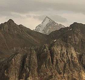
Mount Beshtor
| Beshtor | |
|---|---|
| гора Бештор, гора Беш-Тёр | |
 | |
| Highest point | |
| Elevation | 4,299 m (14,104 ft) |
| Coordinates | 42°06′N 70°52′E / 42.100°N 70.867°ECoordinates: 42°06′N 70°52′E / 42.100°N 70.867°E |
| Geography | |
 Beshtor Location in Uzbekistan | |
| Location | Tashkent, Uzbekistan |
| Parent range | Pskem Mountains |
Mount Beshtor (Russian: гора Бештор, also Беш-Тёр) rises to 4,299 m in Pskem Range in the north-eastern tip of Uzbekistan's Tashkent Province. Located on the southern border with Kyrgyzstan, a short distance to the south-west from another towering peak in Pskem Range, Mount Adelung (Adelunga Toghi, 4,301 m). Beshtor is the second highest peak in both Tashkent Province and the Pskem Range.
References
- Atlas of Soviet Republics of Central Asia, Moscow, 1988, in Russian, p. 22.
- Big Soviet Encyclopedia, on-line edition, in Russian, accessed May 23, 2008.
- Coordinates from MapPlanet, accessed May 23, 2008.
This article is issued from Wikipedia - version of the 9/21/2015. The text is available under the Creative Commons Attribution/Share Alike but additional terms may apply for the media files.