Mount Dana (Alaska)
| Mount Dana | |
|---|---|
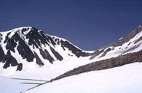
 Crater of Mount Dana | |
| Highest point | |
| Elevation | 1,354 m (4,442 ft) |
| Listing | List of volcanoes in the United States |
| Coordinates | 55°38′28″N 161°12′50″W / 55.641°N 161.214°WCoordinates: 55°38′28″N 161°12′50″W / 55.641°N 161.214°W |
| Geography | |
| Location | Alaska Peninsula, United States |
| Geology | |
| Mountain type | Stratovolcano |
| Volcanic arc/belt | Aleutian Arc |
| Last eruption | 1890 BCE (?) |
Mount Dana is a small stratovolcano of the Alaska Peninsula, United States, located northeast of Canoe Bay inlet at the head of Pavlof Bay. It was the source for a major eruption about 3840 years ago that produced a pyroclastic flow that filled valleys south and west of the volcano's crater and reached the sea at Canoe Bay.[1]
Geography and geology
Dana is northeast of the Canoe Bay inlet, as it sits at the top of Pavlof Bay. It is 555 miles (893 km) from Anchorage.[2]
The United States has the most active volcanoes in the world, many of them geologically young.[3] In Alaska, at least 50 volcanoes, including those in the Aleutian archipelago, have erupted in historical time.[4] The state accounts for ~80% of the United States' volcanoes, excluding the seamounts in the area, ~8% of world volcanoes, and most of these are located among the Aleutian Islands.[4] The Aleutian Islands arc serves as the northern boundary of the Pacific Ring of Fire,[4] where tectonic activity generates earthquakes and volcanic eruptions in masses.
Made up of intermediate composition calc-alkaline rocks, the volcano hosts remnants of an andesite-based dome, just off the western side of the crater and east of Knutson Lake. It resides on submarine sandstone and shale, timed at the Jurassic and Cretaceous eras.[5] Rising 1,354 metres (4,442 ft), the volcano is topped by a crater 1.5 kilometers in height by 2 kilometers in width.[6] To the southwest of the caldera, an exposed sector reveals a layer of sedimentary Mesozoic era stone.[6]
Mount Dana is easily accessible from Canoe Bay, at any time of the year.[7]
Eruptive history
While no recorded eruptions have taken place at the volcano, a flow of blocky lava and volcanic ash is evident on the side of the volcano, streaming into Canoe Bay. Cold springs and an enormous hill of tufa at the volcano also suggest that Dana erupted previously.[6]
References
- ↑ "Dana". Global Volcanism Program. Smithsonian Institution.
- ↑ "Dana description and statistics". United States Geological Survey (USGS), the Geophysical Institute of the University of Alaska Fairbanks (UAFGI), and the State of Alaska Division of Geological and Geophysical Surveys (ADGGS). Retrieved November 21, 2009.
- ↑ Ewert, John; Guffanti, Marianne; Cervelli, Peter; Quick, James (2006). "The National Volcano Early Warning System (NVEWS): U.S. Geological Survey Fact Sheet FS 2006-3142". United States Geological Survey. Retrieved July 9, 2009.
- 1 2 3 "Alaska GeoSurvey News: NL 2008-1". 11 (1). Alaska Division of Geological & Geophysical Surveys. March 2008: 1–14. Retrieved July 9, 2009.
- ↑ Kienle and Wood, p. 54.
- 1 2 3 "Dana - Summary". Global Volcanism Program. Smithsonian Institution. Retrieved November 20, 2009.
- ↑ Kienle and Wood, p. 55.