Mount Frakes
| Mount Frakes | |
|---|---|
 Mounts Frakes (left) and Steere (right) from the northeast. | |
| Highest point | |
| Elevation | 3,675 m (12,057 ft) [1] |
| Prominence | 1,780 m (5,840 ft) [2] |
| Listing | Ultra |
| Coordinates | 76°48′S 117°42′W / 76.800°S 117.700°WCoordinates: 76°48′S 117°42′W / 76.800°S 117.700°W [2] |
| Geography | |
 Mount Frakes Antarctica | |
| Location | Marie Byrd Land, Antarctica |
| Parent range | Crary Mountains |
| Geology | |
| Mountain type | Shield volcano |
| Last eruption | Unknown |
Mount Frakes is a prominent shield volcano marking the highest elevation in the Crary Mountains, in Marie Byrd Land, Antarctica.[1]
The mountain was mapped by the USGS from surveys and U.S. Navy air photos, 1959-66. Named by US-ACAN for Lawrence A. Frakes, United States Antarctic Program geologist who worked three summer seasons in the Falkland Islands and Antarctica, 1964-65 through 1967-68.[1]

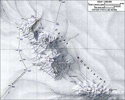
Topographic map of Mounts Frakes and Steere (1:250,000 scale) from USGS Crary Mountains
See also
References
- 1 2 3 U.S. Geological Survey Geographic Names Information System: Mount Frakes
- 1 2 "Antarctica Ultra-Prominences" Peaklist.org. Retrieved 2012-09-06.
Sources
- LeMasurier, W. E.; Thomson, J. W., eds. (1990). Volcanoes of the Antarctic Plate and Southern Oceans. American Geophysical Union. ISBN 0-87590-172-7.
- "Skiing the Pacific Ring of Fire and Beyond". Amar Andalkar's Ski Mountaineering and Climbing Site. 2007 [1997]. Retrieved 2005-01-14.
External links
This article is issued from Wikipedia - version of the 10/23/2016. The text is available under the Creative Commons Attribution/Share Alike but additional terms may apply for the media files.