Mount Scott (Antarctica)
For other uses, see Mount Scott (disambiguation).
| Mount Scott | |
|---|---|
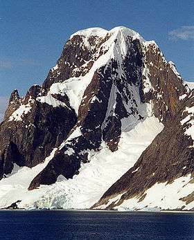
 Mount Scott, February 2001 | |
| Highest point | |
| Elevation | 880 m (2,890 ft) [1] |
| Prominence | 880 m (2,890 ft) |
| Coordinates | 65°09′S 064°03′W / 65.150°S 64.050°W [1] |
| Geography | |
| Location | Graham Land, Antarctica |
Location of Kiev Peninsula in Graham Land, Antarctic Peninsula.
Mount Scott is a horseshoe-shaped massif on Kiev Peninsula, the west coast of Graham Land, which is open to the southwest with its convex side fronting on Girard Bay and its northwestern side on Lemaire Channel.
Discovered by the Belgian Antarctic Expedition, 1897-99. Mapped by Dr. Jean-Baptiste Charcot, leader of the fourth French Antarctic Expedition, 1908–10, and named for Captain Robert Falcon Scott.[1]
References
- 1 2 3 "Mount Scott". Geographic Names Information System. United States Geological Survey. Retrieved 2005-01-26.
This article is issued from Wikipedia - version of the 11/21/2015. The text is available under the Creative Commons Attribution/Share Alike but additional terms may apply for the media files.