Mount Seguam
| Mount Seguam | |
|---|---|
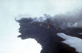 Incandescent lava fountaining from a fissure eruption near Pyre Peak on Seguam Island. | |
| Highest point | |
| Elevation | 3,458 ft (1,054 m) |
| Coordinates | 52°18′54″N 172°30′37″W / 52.31500°N 172.51028°W |
| Geography | |
| Location | Seguam Island, Alaska, U.S. |
| Parent range | Aleutian Range |
| Topo map | USGS Umnak A-2 |
| Geology | |
| Mountain type | Stratovolcano |
| Volcanic arc/belt | Aleutian Arc |
| Last eruption | 1993 |
Mount Seguam is an active stratovolcano on Seguam Island in the Aleutian Islands of Alaska.
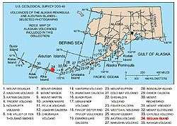
Map showing volcanoes of Alaska. The mark is set at the location of Mount Seguam.
Sources
- "Seguam". Global Volcanism Program. Smithsonian Institution.
- Volcanoes of the Alaska Peninsula and Aleutian Islands-Selected Photographs
- Alaska Volcano Observatory
This article is issued from Wikipedia - version of the 1/2/2016. The text is available under the Creative Commons Attribution/Share Alike but additional terms may apply for the media files.