Mount Washington Wilderness
| Mount Washington Wilderness | |
|---|---|
|
IUCN category Ib (wilderness area) | |
|
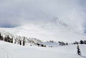
On the route to a winter ascent of Mount Washington | |
 | |
| Location | Linn / Deschutes / Lane counties, Oregon, United States[1] |
| Nearest city | Sisters, Oregon |
| Coordinates | 44°19′55.65″N 121°50′18.70″W / 44.3321250°N 121.8385278°WCoordinates: 44°19′55.65″N 121°50′18.70″W / 44.3321250°N 121.8385278°W |
| Area | 54,278 acres (219.66 km2) |
| Established | 1964 |
| Governing body | U.S. Forest Service |
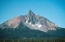
The Mount Washington Wilderness is a wilderness area located on and around Mount Washington in the central Cascade Range of Oregon in the United States. The wilderness was established in 1964 and comprises 54,278 acres (219.66 km2) of the Willamette National Forest and Deschutes National Forest. It is administered by the U.S. Forest Service.[2][3]
Geography
Mount Washington is a shield volcano rising above 75 square miles (190 km2) of lava-strewn plains. The wilderness includes Belknap Crater, a 6,873-foot (2,095 m) cinder and ash volcanic cone. Vegetation consists primarily of lodgepole pine, other species of pine, and mountain hemlock. There are 28 lakes in the wilderness. The Pacific Crest National Scenic Trail extends for 16.6 miles (26.7 km) through the Mount Washington Wilderness. It is the primary trail and extends from the north boundary near Big Lake to where it leaves the wilderness at its southern boundary near the Dee Wright Observatory.[2]

See also
References
- ↑ U.S. National Wilderness Preservation System Map (Map). Wilderness.net. Retrieved June 27, 2014.
- 1 2 "Mount Washington Wilderness: Deschutes". U.S. Forest Service. Retrieved June 27, 2014.
- ↑ "Mount Washington Wilderness". Wilderness.net. Retrieved June 27, 2014.
External links
-
 Media related to Mount Washington Wilderness at Wikimedia Commons
 - Mount Washington Wilderness - Willamette National Forest, U.S. Forest Service
