NAVAREA
NAVAREAs are the geographic areas in which various governments are responsible for navigation and weather warnings.
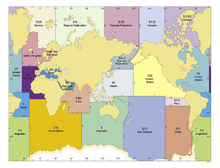
Map of all the NAVAREAs
NAVAREAs are mentioned in International Maritime Organization Assembly Resolution A.706(17) adopted 6 November 1991.
The International Hydrographic Organization publication S-53 has a document entitled "Worldwide Navigational Warnings Service - Guidance Document" which is related to NAVAREAs.[1]
References
External links
- http://www.amsa.gov.au/search%5Fand%5Frescue/distress%5Fand%5Fsafety%5Fcommunications/pdfs/a706%5F17.pdf
- http://www.iho.shom.fr/COMMITTEES/CPRNW/cprnwintro.htm
- http://www.wetterinfobox.com/wib2demo/html/navarea.htm Map of NAVAREAs and schedule for Navtex transmissions
This article is issued from Wikipedia - version of the 2/2/2014. The text is available under the Creative Commons Attribution/Share Alike but additional terms may apply for the media files.