National Register of Historic Places listings in Bryan County, Georgia
This is a list of properties and districts in Bryan County, Georgia that are listed on the National Register of Historic Places (NRHP).
- This National Park Service list is complete through NPS recent listings posted December 16, 2016.[1]
Current listings
| [2] |
Name on the Register |
Image |
Date listed[3] |
Location |
City or town |
Description |
|---|
| 1 |
Bryan County Courthouse |
|
000000001995-06-14-0000June 14, 1995
(#95000713) |
College St.
32°08′00″N 81°37′17″W / 32.13347°N 81.62150°W / 32.13347; -81.62150 (Bryan County Courthouse) |
Pembroke |
|
| 2 |
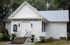
Bryan Neck Presbyterian Church |
|
000000002000-03-15-0000March 15, 2000
(#00000193) |
Belfast Keller Rd.
31°50′30″N 81°15′40″W / 31.841667°N 81.261111°W / 31.841667; -81.261111 (Bryan Neck Presbyterian Church) |
Keller |
|
| 3 |
Fort McAllister |
|
000000001970-05-13-0000May 13, 1970
(#70000197) |
10 mi. E of Richmond Hill via GA 67
31°53′30″N 81°11′42″W / 31.891667°N 81.195°W / 31.891667; -81.195 (Fort McAllister) |
Richmond Hill |
Now a Georgia state historic site website
|
| 4 |
Glen Echo |
|
000000001978-01-09-0000January 9, 1978
(#78000965) |
2 miles (3 km) east of Ellabelle on GA 204
32°08′07″N 81°27′53″W / 32.135278°N 81.464722°W / 32.135278; -81.464722 (Glen Echo) |
Ellabelle |
|
| 5 |
Kilkenny |
|
000000001979-02-14-0000February 14, 1979
(#79000700) |
E of Richmond Hill on Kilkenny Rd.
31°47′24″N 81°12′12″W / 31.78995°N 81.20339°W / 31.78995; -81.20339 (Kilkenny) |
Richmond Hill |
|
| 6 |
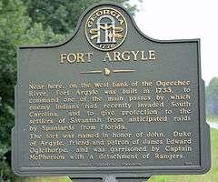
Old Fort Argyle Site |
|
000000001975-03-31-0000March 31, 1975
(#75000574) |
Address Restricted (on the west bank of the Ogeechee River in Fort Stewart)
|
Savannah |
PDF about Fort Argyle
|
| 7 |
Pembroke Historic District |
|
000000002004-12-08-0000December 8, 2004
(#04001318) |
Centered on US 280 and Main St.
32°08′09″N 81°37′24″W / 32.135833°N 81.623333°W / 32.135833; -81.623333 (Pembroke Historic District) |
Pembroke |
|
| 8 |
Richmond Hill Plantation |
|
000000001978-01-30-0000January 30, 1978
(#78000966) |
E of Richmond Hill on Ford Neck Rd.
31°55′33″N 81°16′35″W / 31.92586°N 81.2764°W / 31.92586; -81.2764 (Richmond Hill Plantation) |
Richmond Hill |
On private property (gated)
|
| 9 |
Seven Mile Bend |
|
000000001972-04-11-0000April 11, 1972
(#72000373) |
Address Restricted
|
Richmond Hill |
Facebook page
|
| 10 |
Strathy Hall |
|
000000001979-01-21-0000January 21, 1979
(#79000701) |
SE of Richmond Hill
31°54′14″N 81°15′05″W / 31.903889°N 81.251389°W / 31.903889; -81.251389 (Strathy Hall) |
Richmond Hill |
|
References


.jpg)

