| [2] |
Name on the Register |
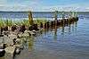
Image |
Date listed[3] |
Location |
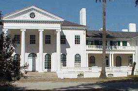
City or town |
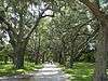
Description |
|---|
| 1 |
Camden County Courthouse |
|
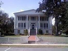
000000001980-09-18-0000September 18, 1980
(#80000983) |
4th and Camden Aves.
30°58′06″N 81°43′14″W / 30.96820°N 81.72069°W / 30.96820; -81.72069 (Camden County Courthouse) |
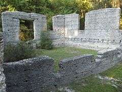
Woodbine |
|
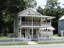
| 2 |
Crooked River Site (9CAM118) |
|
000000001985-12-23-0000December 23, 1985
(#85003179) |
Address Restricted.
|
St. Marys |
Note: may be at Crooked River State Park
|
| 3 |
Duck House |
Upload image |
000000001984-02-13-0000February 13, 1984
(#84000938) |
Cumberland Island
30°50′50″N 81°25′51″W / 30.847222°N 81.430833°W / 30.847222; -81.430833 (Duck House) |
St. Marys |
|
| 4 |
Dungeness Historic District |
|
000000001984-02-13-0000February 13, 1984
(#84000920) |
Address Restricted (on Cumberland Island)
|
St. Marys |
|
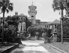
| 5 |
Greyfield |
Upload image |
000000002003-07-24-0000July 24, 2003
(#03000675) |
Cumberland Island
30°46′51″N 81°27′51″W / 30.780833°N 81.464167°W / 30.780833; -81.464167 (Greyfield) |
Camden |
|
| 6 |
High Point-Half Moon Bluff Historic District |
Upload image |
000000001978-12-22-0000December 22, 1978
(#78000265) |
NE of St. Marys on Cumberland Island
30°55′14″N 81°25′56″W / 30.920556°N 81.432222°W / 30.920556; -81.432222 (High Point-Half Moon Bluff Historic District) |
St. Marys |
|
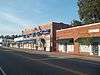
| 7 |
Kingsland Commercial Historic District |
|
000000001994-03-17-0000March 17, 1994
(#94000186) |
Area surrounding S. Lee St. (US 17), between King and William Sts.
30°47′58″N 81°41′26″W / 30.799444°N 81.690556°W / 30.799444; -81.690556 (Kingsland Commercial Historic District) |
Kingsland |
|
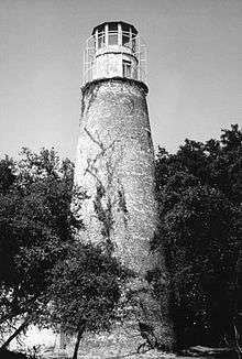
| 8 |
Little Cumberland Island Lighthouse |
|
000000001989-08-28-0000August 28, 1989
(#89001407) |
N end of Little Cumberland Island
30°58′34″N 81°24′47″W / 30.97621°N 81.41310°W / 30.97621; -81.41310 (Little Cumberland Island Lighthouse) |
St. Marys |
|
| 9 |
Main Road |
|
000000001984-02-13-0000February 13, 1984
(#84000941) |
Cumberland Island
30°49′45″N 81°27′26″W / 30.829167°N 81.457222°W / 30.829167; -81.457222 (Main Road) |
St. Marys |
|
| 10 |
John Houstoun McIntosh Sugarhouse |
|
000000001992-04-02-0000April 2, 1992
(#92000167) |
Ga. Spur 40, 6 mi. N of St. Marys, access is from Charlie Smith Hwy. (at 30°47′35″N 81°34′38″W / 30.79310°N 81.57712°W / 30.79310; -81.57712)
30°47′36″N 81°34′43″W / 30.79328°N 81.57870°W / 30.79328; -81.57870 (John Houstoun McIntosh Sugarhouse) |
St. Marys |
|
| 11 |
Orange Hall |
|
000000001973-05-07-0000May 7, 1973
(#73000613) |
311 Osborne St.
30°43′28″N 81°32′53″W / 30.72431°N 81.54811°W / 30.72431; -81.54811 (Orange Hall) |
St. Marys |
|
| 12 |
Plum Orchard Historic District |
|
000000001984-11-23-0000November 23, 1984
(#84000258) |
Address Restricted (on Cumberland Island)
|
St. Marys |
|
| 13 |
Rayfield Archeological District |
Upload image |
000000001984-02-13-0000February 13, 1984
(#84000924) |
Address Restricted
|
St. Marys |
|
| 14 |
St. Marys Historic District |
|
000000001976-05-13-0000May 13, 1976
(#76000609) |
Roughly bounded by Waterfront Rd., Norris, Alexander, and Oak Grove Cemetery
30°44′36″N 81°33′24″W / 30.743333°N 81.556667°W / 30.743333; -81.556667 (St. Marys Historic District) |
St. Marys |
|
| 15 |
Stafford Plantation |
|
000000001984-11-23-0000November 23, 1984
(#84000265) |
Address Restricted (on Cumberland Island)
|
St. Marys |
The only surviving antebellum-era structures are "the chimneys," slave cabin ruins.
|
| 16 |
Table Point Archeological District |
Upload image |
000000001984-11-23-0000November 23, 1984
(#84000260) |
Address Restricted
|
St. Marys |
|
| 17 |
Woodbine Historic District |
|
000000001999-05-12-0000May 12, 1999
(#99000553) |
Jct. of Bedell Ave. (US 17) and 3rd and 4th Sts.
30°58′04″N 81°43′27″W / 30.967778°N 81.724167°W / 30.967778; -81.724167 (Woodbine Historic District) |
Woodbine |
|
%2C_Woodbine%2C_GA%2C_US.jpg)