Navajo Dam
| Navajo Dam Daʼdeestłʼin (Navajo) | |
|---|---|
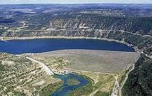
 View of Navajo Dam from the air | |
| Country | United States |
| Location | San Juan and Rio Arriba Counties, New Mexico |
| Coordinates | 36°48′01″N 107°36′45″W / 36.80028°N 107.61250°WCoordinates: 36°48′01″N 107°36′45″W / 36.80028°N 107.61250°W |
| Status | In use |
| Construction began | 1957 |
| Opening date | 1962 |
| Owner(s) | U.S. Bureau of Reclamation |
| Dam and spillways | |
| Type of dam | Rolled earthfill embankment |
| Impounds | San Juan River |
| Height | 402 ft (123 m) |
| Length | 3,648 ft (1,112 m) |
| Dam volume | 26,840,863 cu yd (20,521,312 m3) |
| Spillways | 1 |
| Spillway type | Service, concrete uncontrolled overflow |
| Spillway capacity | 34,000 cu ft/s (960 m3/s) |
| Reservoir | |
| Creates | Navajo Lake |
| Total capacity | 1,708,600 acre·ft (2.1075 km3) |
| Catchment area | 3,190 sq mi (8,300 km2) |
| Surface area | 15,610 acres (6,320 ha) |
| Power station | |
| Operator(s) | City of Farmington |
| Commission date | 1983 |
| Hydraulic head | 381.6 ft (116.3 m) |
| Turbines | 1 |
| Installed capacity | 32 MW |
| Annual generation | 130,810,000 KWh[1] |
Navajo Dam is an earthen dam on the San Juan River, a tributary of the Colorado River, in northwestern New Mexico in the United States. The dam and its reservoir, Navajo Lake, lie in the arid western foothills of the Rocky Mountains about 30 miles (48 km) east of Farmington.
History
This dam was built as part of the Colorado River Storage Project, a massive system of dams and reservoirs across the upper Colorado River Basin, by the U.S. Bureau of Reclamation. Although the first studies for a dam on the San Juan were made as early as 1904, it was not considered seriously until the 1930s with the onset of heavy water use in the Colorado watershed. Construction started in 1957 and was completed on September 15, 1962. Today it is one of four major storage facilities for the project – Glen Canyon, Blue Mesa and Flaming Gorge are the three others.[2]
The construction of the dam and the resulting lake flooded and destroyed one of the Navajos' most sacred sites.[3]
Dimensions
The Navajo Dam is 402 feet (123 m) high and 3,648 feet (1,112 m) long. Its crest is at an elevation of 6,108 feet (1,862 m).[4] The reservoir formed behind the dam, Navajo Lake, is 35 miles (56 km) long and stores 1,708,600 acre feet (2.1075 km3) of water. The dam has one spillway, an ungated concrete chute capable of discharging 34,000 cubic feet per second (960 m3/s).[5]
Power generation
Despite its location on a major river and its massive height, the dam was built solely for storage purposes and thus did not have a power plant when construction was completed in 1962. Between 1974–1976, the city of Farmington contracted with Reclamation to build a 23 MW hydroelectric plant at the base of the dam. Due to environmental and legal concerns, construction was not completed until 1983. The plant was later uprated to a capacity of 32 MW.[6]
See also
References
- ↑ http://carma.org/plant/detail/30651
- ↑ "Navajo Dam". Colorado River Storage Project. U.S. Bureau of Reclamation. 2008-11-25. Retrieved 2011-02-11.
- ↑ Linford, Laurance. Navajo Places. History, Legend, Landscape. University of Utah Press. Salt Lake City: 2000.
- ↑ "Dimensions". Colorado River Storage Project. U.S. Bureau of Reclamation. 2010-04-13. Retrieved 2011-02-11.
- ↑ "Hydraulics & Hydrology". Colorado River Storage Project. U.S. Bureau of Reclamation. 2010-04-13. Retrieved 2011-02-11.
- ↑ "Electricity History of Farmington, New Mexico" (PDF). City of Farmington. Retrieved 2011-02-11.


