Norfield Historic District
|
Norfield Historic District | |
|
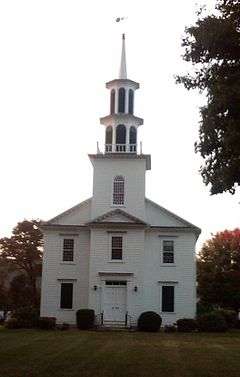
Norfield Congregational Church | |
  | |
| Location | Roughly, jct. of Weston and Norfield Rds. NE to Hedgerow Common, Weston, Connecticut |
|---|---|
| Coordinates | 41°12′4″N 73°22′44″W / 41.20111°N 73.37889°WCoordinates: 41°12′4″N 73°22′44″W / 41.20111°N 73.37889°W |
| Area | 18 acres (7.3 ha) |
| Architectural style | Colonial Revival, Greek Revival, Federal |
| NRHP Reference # | 91000955[1] |
| Added to NRHP | July 31, 1991 |
The Norfield Historic District is a 18-acre (7.3 ha) historic district in Weston, Connecticut that was listed on the National Register of Historic Places in 1991.[1] It includes the present-day town center of Weston, which was known as Norfield during 1795-1920.[2]
It was listed for its meeting architectural criteria, and included 16 contributing buildings.[1] The district includes a total of 25 institutional and residential buildings, of which nine are more modern and non-contributing including the town hall and town library. The Norfield Congregational Church is the most prominent building.[2]
Norfield Congregational Church
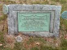
Built in 1757, the church is located at 64 Norfield Road and still holds Sunday services.[3] The church property includes the Christian Education Building, a parish hall, a parking area, a memorial garden and a front lawn including the Weston World War II memorial.[4]

See also
References
- 1 2 3 National Park Service (2009-03-13). "National Register Information System". National Register of Historic Places. National Park Service.
- 1 2 Jan Cunningham (January 7, 1991). "National Register of Historic Places Registration: Norfield Historic District" (PDF). National Park Service. and Accompanying nine photos, from 1990 (see photo captions pages and map pages 14-15 of text document)
- ↑ http://www.norfield.org/
- ↑ http://www.norfield.org/AboutNorfield/ChurchCampus/tabid/26157/Default.aspx
