North Pack Monadnock
- This article is about a mountain located in Greenfield and Temple, New Hampshire. It Should not be confused with the nearby Mount Monadnock. For other uses, see Monadnock (disambiguation)
| North Pack Monadnock | |
|---|---|
 View of the Pack Monadnocks from Mount Monadnock; North Pack is on the left | |
| Highest point | |
| Elevation | 2,276 ft (694 m) |
| Prominence | 538 ft (164 m) |
| Coordinates | 42°53′10″N 71°51′56″W / 42.88611°N 71.86556°W |
| Geography | |
| Location | Greenfield and Temple, New Hampshire |
| Parent range | Wapack Range |
| Geology | |
| Age of rock | 400 million years |
| Mountain type | monadnock; metamorphic rock |
| Climbing | |
| Easiest route | Wapack Trail |
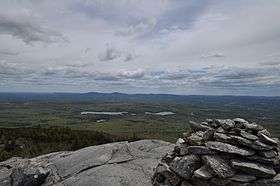
North Pack Monadnock or North Pack Monadnock Mountain is a 2,276-foot (694 m) monadnock in south-central New Hampshire, at the northern end of the Wapack Range of mountains. It lies within Greenfield and Temple, New Hampshire; the 22-mile (35 km) Wapack Trail traverses the mountain. Ledges on the summit offer long views north to the White Mountains and west to Mount Monadnock. Pack Monadnock Mountain is directly to the south along the Wapack ridgeline. The upper elevations of the mountain are within Miller State Park.
According to local tradition, the word "pack" is a Native American word for "little"; "monadnock" is used to describe an isolated mountain summit. Thus "Pack Monadnock" (Little Monadnock) refers to its relationship to the higher Mount Monadnock, 3,165 feet (965 m), 11 miles (18 km) to the west. It should not be confused with the similarly named peak Little Monadnock Mountain, 17 miles (27 km) to the west.
The east side of the mountain drains into the Souhegan River watershed, thence into the Merrimack River and Atlantic Ocean; the west side drains into the Contoocook River, thence into the Merrimack River.
References
- Southern New Hampshire Trail Guide (1999). Boston: The Appalachian Mountain Club.