Northeast U.S. flooding of October 2005

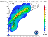
In October 2005, remnants of Tropical Storm Tammy and Subtropical Depression Twenty-Two merged with incoming continental cold fronts to produce torrential rains over interior New England, as well as over parts of New Jersey and New York. Particularly hard hit was the state of New Hampshire, which saw roads and bridges wiped out, several reported deaths, and whole buildings destroyed. Rain lingered over some areas for several weeks. Rainfall from both rain events totaled well over 20 inches (510 mm) in some areas.
Effects by state

Rhode Island
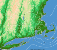
With 14.94 inches (379 mm) of rain in October 2005, T. F. Green Airport recorded its wettest month ever. During October 13–15, rainfall was heaviest in central and eastern Massachusetts and Rhode Island. The NWS reported rainfall amounts of 4 to 7 inches (100 to 175 mm) in central and eastern Massachusetts and 7 to 9 inches (175 to 225 mm) in Rhode Island. A state of emergency was declared for the state, and thousands were without power. At least 100 residents were evacuated after swift rises in local rivers, and Red Cross shelters were set up throughout the state. The Pawtuxet River, at Cranston and Warwick, recorded its second-worst flood, at a stage of 13.68 feet (4.17 m). The Blackstone River, at Woonsocket, also recorded its second-worst flood, at a stage of 15.34 feet (4.68 m). The Woonasquatucket River in Providence and Central Falls recorded a new flood record, at 8.3 feet (2.53 m).[1] Damage in Rhode Island totaled $1.6 million (2005 USD).[2]
Connecticut
Thousands of homes and businesses lost power, primarily in Bridgeport. Localized flooding was reported in certain areas of Connecticut: one death occurred when a woman was swept away at Diana's Pool on the Natchaug River, another death occurred when a man was swept away by the raging waters in a campground in Stafford Springs, and another woman fell into the churning Connecticut River. In addition, the rains softened the soil, creating mudslides that damaged a lengthy stretch of railroad tracks near Naugatuck, interrupting service. Residents in low-lying areas of Shelton, Seymour, Stratford, and Oxford were evacuated as heavy rains forced the Housatonic River out of its banks, inundating homes and businesses. It was the wettest October on record for Hartford.[3] Damage totaled to $6 million (2005 USD).[4]
Massachusetts
Severe inland flooding resulted in $6.5 million in damage. In Greenfield, a trailer park was destroyed, leaving at least 70 people homeless. Officials evacuated 2,000 residents of Taunton when the failing Whittenton Pond Dam threatened to collapse and submerge the city under 8 feet (2.44 meters) of water.[5] The Massachusetts National Guard drained the reservoir behind the 173-year wooden dam using five high-volume pumps. Once the reservoir was drained, evacuees were allowed to return to their homes, and the Army Corps of Engineers removed the old structure and replaced it with an earthen dam.[6]
New Hampshire
The state of New Hampshire was one of the hardest hit from flooding and mudslides, particularly in the southwestern part. The town of Alstead was especially hard hit, as the Cold River and its tributaries substantially overflowed due to the heavy rain and water flowing downstream, inundating the community. The city of Keene received over 14 inches (360 mm) of rain, flooding communities near Beaver Brook and the lower Ashuelot River. More than 1,000 people were forced to evacuate their homes in the region. Seven deaths were confirmed in the state. In some areas, entire houses were washed off of their foundations.[7] Damages totaled $15.8 million (2005 USD), primarily in Cheshire County.[8][9] The storm dropped nearly 18 inches (460 mm) of liquid precipitation, including nearly 3 feet (910 mm) of snow on the summit of Mount Washington, as recorded by the Mount Washington Observatory. This contributed to a record-setting month on the peak with "the world's worst weather," which recorded 28.7 inches (730 mm) of rain, a record for any month since 1934, and 78.9 inches (2,000 mm) of snow, a record for the month of October.[10]
New Jersey
Flooding was reported in several parts of northern New Jersey. Bergen and Passaic counties were hardest hit, as floodwaters covered several communities to varying degrees. In most places, flooding was the worst seen since 1999's Hurricane Floyd.
Several rivers, including the Pequannock River, Passaic River and Ramapo River, overflowed their banks. Evacuation orders were issued for parts of the towns of Bound Brook, Lodi, Oakland and Westwood during the peak of the flooding. Coastal flooding was also reported along parts of the Jersey Shore.[11] A statewide state of emergency was declared by Governor Richard Codey.[3]
New York
Coastal flooding was a problem on Long Island, and severe beach erosion was reported in many areas.[12] It was the wettest October on record for Central Park.[13]
Maine
Minor to moderate flooding occurred across the southern half of the state, in such cities as Portland, Bar Harbor, and Bangor. In Bangor, a total of 13.32 inches (338 mm) of rain was measured during the month, making it the rainiest month in history.
See also
Notes
- ↑ Advanced Hydrological Prediction Service (2008). "Woonasquatucket River water level". Retrieved 2008-01-20.
- ↑ NCDC: Event Details
- 1 2 http://www.heraldonline.com/24hour/nation/story/2805391p-11439248c.html
- ↑ NCDC: Event Details
- ↑ U.S. Officials still fear dam collapse, CNN.com, October 18, 2005
- ↑ Unstable dam in Taunton replaced, Boston Globe, October 23, 2005
- ↑ http://www.rednova.com/news/general/271071/drenched_northeastern_us_braces_for_more_rain/index.html?source=r_general
- ↑ NCDC: Event Details
- ↑ NCDC: Event Details
- ↑ http://www.mountwashington.org/weather/f6/2005/10.pdf
- ↑ wcbstv.com - New Jersey Flooding Gets Much Worse
- ↑ wcbstv.com - Long Islanders Suffer In The Floodwaters
- ↑ NCDC: October 2005 City/State Extremes
External links
- The HPC archive for the first event.
- The HPC archive for the second event.