Nova Scotia Route 331
| ||||
|---|---|---|---|---|
| Route information | ||||
| Maintained by Nova Scotia Department of Transportation and Infrastructure Renewal | ||||
| Length: | 57 km[1] (35 mi) | |||
| Major junctions | ||||
| South end: |
| |||
| North end: |
| |||
| Location | ||||
| Counties: | Queens Municipality, Lunenburg | |||
| Highway system | ||||
|
Provincial highways in Nova Scotia
| ||||
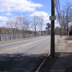
Route 331 outside Bridgewater beside the Lahave River.
Route 331 is a collector road in the Canadian province of Nova Scotia.
It is located on the province's South Shore, connecting East Medway at Highway 103 with Bridgewater at Route 325.
Communities
- East Port Medway
- Vogler's Cove
- Cherry Hill
- Broad Cove
- Petite Rivière
- Crescent Beach
- West Dublin
- Dublin Shore
- LaHave
- Pentz
- West LaHave
- Pleasantville
- Conquerall Bank
- Bridgewater
Parks
- Rissers Beach Provincial Park
- Bush Island Provincial Park
History
The entirety of Collector Highway 331 was once designated as Trunk Highway 31.
See also
References
- ↑ Atlantic Canada Back Road Atlas ISBN 978-1-55368-618-7 Page 87
This article is issued from Wikipedia - version of the 6/19/2016. The text is available under the Creative Commons Attribution/Share Alike but additional terms may apply for the media files.