Ohio State Route 450
| ||||
|---|---|---|---|---|
 | ||||
| Route information | ||||
| Maintained by ODOT | ||||
| Length: | 1.06 mi[1] (1.71 km) | |||
| Existed: | 2004 – present | |||
| Major junctions | ||||
| West end: | Milford Parkway in Milford | |||
|
| ||||
| East end: |
| |||
| Location | ||||
| Counties: | Clermont | |||
| Highway system | ||||
| ||||
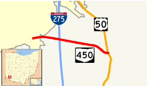
State Route 450 (SR 450) is a short east–west state highway in southwestern Ohio, specifically near the eastern Cincinnati suburb of Milford. The western terminus of State Route 450 is at the Milford city limits, just west of a partial cloverleaf interchange with Interstate 275, with the road continuing into Milford known as Milford Parkway, which passes by the River's Edge Shopping Center and several distribution-oriented businesses prior to meeting U.S. Route 50 at the intersection marking the western terminus of State Route 131. State Route 450's eastern terminus is at U.S. Route 50, less than 1-mile (1.6 km) east of Interstate 275.
State Route 450's primary function is as a connector route between Interstate 275 and U.S. Route 50, as there is no direct access between the two routes at the point where U.S. Route 50 passes underneath Interstate 275.
Route description
The point where Milford Parkway meets the city limits of Milford just west of Exit 59 off of Interstate 275 marks the beginning of State Route 450. Heading easterly from there into Union Township, the four-lane divided State Route 450 intersects Interstate 275 at a seven-ramp partial cloverleaf interchange with the only bi-directional ramp being the one connecting State Route 450 with northbound Interstate 275. East of the freeway, State Route 450 crosses over the East Fork of the Little Miami River, after which the median widens out prior to the state route's endpoint at a signalized intersection with U.S. Route 50.[2]
For its entire length, just over 1 mile (1.6 km), there are no driveways along State Route 450. Besides the connection with Milford Parkway at its western end, the only other access points to State Route 450 are at the Interstate 275 interchange and the U.S. Route 50 intersection.[2]
History
State Route 450 was established on November 22, 2004, along a formerly unsigned highway that had been given an internal designation of U.S. Route 50T by the Ohio Department of Transportation.[3]
Major intersections
The entire route is in Clermont County.
| Location | mi[1] | km | Destinations | Notes | |
|---|---|---|---|---|---|
| Union Township | 0.00 | 0.00 | CR 500 (Milford Parkway) | Western terminus at Milford city limits. | |
| 0.06– 0.62 | 0.097– 1.00 | Seven-ramp parclo interchange. | |||
| Miami Township | 1.06 | 1.71 | Eastern terminus at signalized intersection. | ||
| 1.000 mi = 1.609 km; 1.000 km = 0.621 mi | |||||
References
- 1 2 Ohio Department of Transportation. "Technical Services Straight Line Diagrams" (PDF). Retrieved 2013-12-31.
- 1 2 Google (October 27, 2015). "Ohio State Route 450" (Map). Google Maps. Google. Retrieved October 27, 2015.
- ↑ Ohio Department of Transportation. "Technical Services Straight Line Diagrams: US Route 50T" (PDF). Archived from the original (PDF) on September 27, 2004. Retrieved 2013-12-31.
