Ohio State Route 608
| ||||
|---|---|---|---|---|
 | ||||
| Route information | ||||
| Maintained by ODOT | ||||
| Length: | 19.47 mi[1] (31.33 km) | |||
| Existed: | 1938[2][3] – present | |||
| Major junctions | ||||
| South end: |
| |||
| North end: | Ravenna Road (C-360) in Concord Township | |||
| Location | ||||
| Counties: | Geauga, Lake | |||
| Highway system | ||||
| ||||

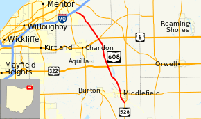
State Route 608 (SR 608) is a north–south state highway in the northeastern portion of the U.S. state of Ohio. Its southern terminus is at State Route 528 about 2 miles (3.2 km) south of Middlefield. The northern terminus is at Ravenna Road (Lake County Road 360, former State Route 44) about 4 miles (6.4 km) south of Painesville. The route passes through one of the largest Amish settlements in Ohio; an Amish-run cheese factory is located at Nauvoo Road north of Middlefield.
History
SR 608 follows part of the Old State Road, which was constructed in 1805 between Painesville and Warren.[4] SR 608 was original commissioned in 1938, between SR 87 and its current northern terminus.[2][3] The entire route was paved by 1949.[5][6] The route was extended south to its current southern terminus, at SR 528, in 1965. In that same year SR 44 was rerouted westward, leaving the northern terminus of SR 608 disconnected from the state route system.[7][8]
Major intersections
| County | Location | mi[1] | km | Destinations | Notes |
|---|---|---|---|---|---|
| Geauga | Middlefield Township | 0.00 | 0.00 | ||
| Middlefield | 2.09 | 3.36 | |||
| Claridon Township | 7.53 | 12.12 | |||
| Hambden Township | 12.84 | 20.66 | |||
| Lake | Concord Township | 19.47 | 31.33 | CR 360 (Ravenna Road) / CR 412 (Concord Hambden Road) | |
| 1.000 mi = 1.609 km; 1.000 km = 0.621 mi | |||||
References
- 1 2 Ohio Department of Transportation. "Technical Services Straight Line Diagrams". Retrieved April 30, 2010.
- 1 2 Ohio Department of Highways (1937). Official Highway Map of Ohio (MrSID) (Map). 1:633,600. Columbus: Ohio Department of Highways. OCLC 5673562, 16960304. Retrieved August 29, 2013.
- 1 2 Ohio Department of Highways (1938). Official Highway Map of Ohio (MrSID) (Map). 1:633,600. Columbus: Ohio Department of Highways. OCLC 5673562, 7453129. Retrieved August 29, 2013.
- ↑ Upton, Harriet Taylor; Harry Gardner Cutler (1910). History of the Western Reserve. 1. Chicago: The Lewis Publishing Company. pp. 330–331.
- ↑ Ohio Department of Highways (1948). Official Highway Map of Ohio (MrSID) (Map). 1:633,600. Columbus: Ohio Department of Highways. OCLC 5673562, 7412169. Retrieved August 29, 2013.
- ↑ Ohio Department of Highways (1949). Official Highway Map of Ohio (MrSID) (Map). 1:633,600. Columbus: Ohio Department of Highways. OCLC 5673562, 13655762. Retrieved August 29, 2013.
- ↑ Ohio Department of Highways (1964). Official Highway Map of Ohio (MrSID) (Map). Columbus: Ohio Department of Highways. OCLC 5673562, 7448791. Retrieved August 29, 2013.
- ↑ Ohio Department of Highways (1965). Official Highway Map of Ohio (MrSID) (Map). Columbus: Ohio Department of Highways. OCLC 5673562, 7438626, 28530064. Retrieved August 29, 2013.