Ohio State Route 91
| ||||
|---|---|---|---|---|
 | ||||
| Route information | ||||
| Maintained by ODOT | ||||
| Length: | 44.12 mi[1] (71.00 km) | |||
| Existed: | 1924 – present | |||
| Major junctions | ||||
| South end: |
| |||
|
| ||||
| North end: |
| |||
| Location | ||||
| Counties: | Summit, Cuyahoga, Lake | |||
| Highway system | ||||
| ||||

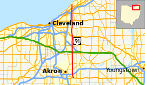
State Route 91 (SR 91) is a north–south state highway in the northeastern portion of the U.S. state of Ohio. Its southern terminus is at U.S. Route 224 (East Waterloo Road) in Springfield Township, east of Akron. Its northern terminus is at State Route 283 (Lake Shore Boulevard) on the Timberlake/Eastlake border less than one mile (1.6 km) south of Lake Erie.
The route is known as "Canton Road" from its southern terminus to just north of its interchange with Interstate 76 (Canton Road continues south as County Route 66,[2] a former portion of State Route 8). North of this interchange, it is called "Darrow Road" until it enters the city of Tallmadge, where it is named "South Avenue" south of the Tallmadge Circle, and "North Avenue" north of the circle. It next passes through the Munroe Falls village limits and is known as "South Main Street" and "North Main Street." It becomes "Darrow Road" once again in the city of Stow and for its remaining length in Summit County, aside from within the Hudson city limits, where it is "South" and "North Main Street."
In Cuyahoga and Lake Counties, State Route 91 is known as "SOM Center Road," named for the fact that it runs through the centers of the original Solon, Orange and Mayfield Townships in Cuyahoga County.[3]
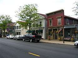
The State Route 91 corridor includes views of some of the best examples of Connecticut Western Reserve town planning, particularly the quaint public squares of Hudson, Tallmadge, and Mayfield. It also dissects several other picturesque and affluent communities of Northeast Ohio, including Gates Mills, Pepper Pike, Hunting Valley, Moreland Hills and Solon (which also has remnants of a Western Reserve public square).
History
- 1924 – Original route established.[4] Originally routed from Tallmadge to 3 miles (4.8 km) east of Wickliffe.[5]
- 1926 – Extended south to 3 miles (4.8 km) north of Lakemore along a previously unnumbered road.[5]
- 1966 – Upgraded to 4 lanes from U.S. Route 6 to 3 miles (4.8 km) east of Wickliffe by this time.[5]
- 1970 – Extended south to Springfield Township along the former State Route 8 alignment; extended north to Eastlake as a divided highway.[5]
Major intersections
| County | Location | mi[1] | km | Destinations | Notes |
|---|---|---|---|---|---|
| Summit | Springfield Township | 0.00 | 0.00 | ||
| Akron | 1.81 | 2.91 | Eastern terminus of SR 18 | ||
| Tallmadge | 5.01– 5.10 | 8.06– 8.21 | Tallmadge Circle | ||
| Stow | 9.10 | 14.65 | |||
| Hudson | 14.67 | 23.61 | |||
| Twinsburg | 19.15– 19.26 | 30.82– 31.00 | Exit 37 (I-480) | ||
| 19.60 | 31.54 | ||||
| Cuyahoga | Solon | 24.71 | 39.77 | ||
| 25.32– 25.52 | 40.75– 41.07 | Exit 18 (US 422) | |||
| Pepper Pike | 30.00 | 48.28 | |||
| Mayfield Heights | 34.20 | 55.04 | |||
| Lake | Willoughby Hills | 38.86 | 62.54 | ||
| 39.66– 40.00 | 63.83– 64.37 | Exit 189 (I-90) | |||
| Willoughby | 40.23 | 64.74 | |||
| 41.45 | 66.71 | ||||
| Eastlake | 42.15– 42.26 | 67.83– 68.01 | Exit 211 (SR 2) | ||
| 42.68 | 68.69 | ||||
| 44.12 | 71.00 | ||||
| 1.000 mi = 1.609 km; 1.000 km = 0.621 mi | |||||
References
- 1 2 "DESTAPE". Ohio Department of Transportation. July 16, 2013. Retrieved September 21, 2014.
- ↑ Official Summit County 2005 Highway Map, Summit County Engineer
- ↑ Sartin, V. David (2007-08-31). "SOM Center Road has origins in three townships". PD Extra. Retrieved 2009-07-20.
- ↑ Explanation of the Ohio State Highway System (The Unofficial Ohio State Highways Web Site) by John Simpson Archived May 23, 2006, at the Wayback Machine.
- 1 2 3 4 Route 91 (The Unofficial Ohio State Highways Web Site) by John Simpson Archived December 26, 2004, at the Wayback Machine.