Oosterpark (Amsterdam)
| Oosterpark | |
|---|---|
|
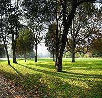
A field of grass in the Oosterpark | |
| Type | Urban park |
| Location | Oost/Watergraafsmeer, Amsterdam, Netherlands |
| Status | Open all year |
The Oosterpark in Amsterdam is the first large park laid out by the municipality of Amsterdam. The park is located in the Oost/Watergraafsmeer borough and forms a component of the Oosterpark area. The park, an English garden, was designed by Dutch landscape architect Leonard Anthony Springer and was laid out in 1891.
Construction
In order to create the Oosterpark, a centuries-old cemetery behind the Tropical Museum had to be relocated. There were a lot of protests at the time when the municipality of Amsterdam suggested the new plans. In the end the protesters gave in and agreed with the new location for "their" cemetery which is now known as the New Ooster Begraafplaats. In the park is a pond with a small island. The park also contains a part of the former cemetery.
National Slavery Monument
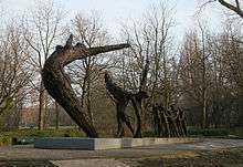
The park contains The National Slavery Monument, which commemorates the abolition of slavery in the Netherlands in 1863. The monument was unveiled on July 1, 2002 in the presence of Her Majesty Queen Beatrix. The dynamic dimension of the monument, the National Institute for Dutch Slavery and its Legacy (NiNsee) was opened on July 1, 2003. Every year on July 1, NiNsee commemorates the abolition of Dutch Slavery in the Oosterpark with the Keti Koti festival.
Memorial

The Oosterpark also contains a memorial to Theo van Gogh, a film maker and controversial columnist who in 2004 was murdered nearby by a Muslim extremist.

Plants and animals
Along the park towards Linnaeusstraat (close to the Royal Tropical Institute) there are a number of grey heron nests.

The streets lining the southern and western borders of the park are also called Oosterpark. Originally these streets were called Eerste Parkstraat ("First Park Street").
References
| Wikimedia Commons has media related to Oosterpark. |
Coordinates: 52°21′35″N 4°55′15″E / 52.35972°N 4.92083°E
