Orford Street Historic District
|
Orford Street Historic District | |
|
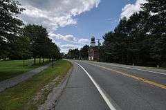
Promenade on the left, Masonic Hall in the distance on the right | |
  | |
| Location | Orford St. (NH 10) from Rt. 25A to Archertown Rd., E to include cemetery, Orford, New Hampshire |
|---|---|
| Coordinates | 43°54′16″N 72°08′07″W / 43.904444°N 72.135278°WCoordinates: 43°54′16″N 72°08′07″W / 43.904444°N 72.135278°W |
| Area | 43.2 acres (17.5 ha) |
| Architectural style | Greek Revival, Late Victorian, Federal |
| NRHP Reference # | 77000163[1] |
| Added to NRHP | August 26, 1977 |
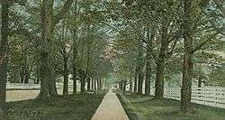
The Orford Street Historic District encompasses a particularly attractive stretch of Orford Street (New Hampshire Route 10) in Orford, New Hampshire. It was described as early as the 18th century as "the most charming country village", with a tree-lined promenade that is still a focus of the town center. The district consists of about 0.5 miles (0.80 km) of Orford Street, between its junctions with New Hampshire Route 25A and Archertown Road, and was listed on the National Register of Historic Places in 1977.[1][2]
The west side of Orford Street lies between the street and the Connecticut River, and is lined with a series of 18th and 19th century residential and civic buildings. Prominent among them are a series of Federal-style houses, built between 1773 and 1839, along what is called The Ridge, the brick Masonic hall (1840, formerly a Universalist church), and the 1851 academy. The east side of the street is dominated by a large common with tree-lined promenade.[2]

See also
| Wikimedia Commons has media related to Orford Street Historic District. |
References
- 1 2 National Park Service (2010-07-09). "National Register Information System". National Register of Historic Places. National Park Service.
- 1 2 "NRHP nomination for Orford Street Historic District" (PDF). National Park Service. Retrieved 2014-04-16.

