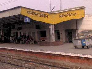
Panipat Junction railway station
Panipat | |
|---|---|
| Indian Railway Junction Station | |
 | |
| Location |
Idgah Road, Model Town, Panipat, Haryana India |
| Coordinates | 29°23′20″N 76°57′50″E / 29.389°N 76.964°ECoordinates: 29°23′20″N 76°57′50″E / 29.389°N 76.964°E |
| Elevation | 235 metres (771 ft) |
| Owned by | Indian Railways |
| Operated by | Northern Railway |
| Line(s) |
Delhi-Kalka line Panipat-Jind branch line |
| Tracks | Broad gauge 1,676 mm (5 ft 6 in) |
| Construction | |
| Structure type | Standard on ground |
| Parking | Yes |
| Bicycle facilities | No |
| Other information | |
| Status | Functioning |
| Station code | PNP |
| Division(s) | Delhi |
| History | |
| Opened | 1897 |
| Location | |
 Panipat railway station Location in Haryana | |
Panipat railway station is located in Panipat district in the Indian state of Haryana and serves the historic and industrial town of Panipat .
The Railway Station
Panipat Railway Station is at an elevation of 235 metres (771 ft) and was assigned the code – PNP.[1]
History
The Delhi-Ambala-Kalka line was opened in 1891.[2]
The foundation stone for the shifting of Rohtak- Makrauli section of Rohtak- Gohana- Panipat line was laid in 2013.[3]
Electrification
Sabjimandi-Karnal sector was electrified in 1992-1995.[4]
References
- ↑ "Arrivals at Panipat Junction". indiarailinfo. Retrieved 1 March 2014.
- ↑ "IR History: Early Days II (1870-1899)". IRFCA. Retrieved 3 March 2014.
- ↑ "Minister for Railways Sh. Mallikarjun Kharge lays the foundation stones of 'Rohtak-Meham-Hansi new line and shifting of Rohtak-Makrauli section of Rohtak-Gohana-Panipat section today". Northern Railway. Retrieved 3 March 2014.
- ↑ "History of Electrification". IRFCA. Retrieved 3 March 2014.
External links
- Trains at Panipat
-
 Panipat travel guide from Wikivoyage
| Preceding station | Indian Railways | Following station | ||
|---|---|---|---|---|
Samalkha | Northern Railway zone | Babarpur |
||
| Terminus | Northern Railway zone | Madlauda |
||
| Terminus | Northern Railway zone Panipat-Rohtak line | Binjhol |
This article is issued from Wikipedia - version of the 4/23/2016. The text is available under the Creative Commons Attribution/Share Alike but additional terms may apply for the media files.