Pavla Vas
| Pavla Vas | |
|---|---|
|
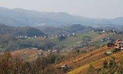
Pavla Vas, view from Slančji Vrh | |
 Pavla Vas Location in Slovenia | |
| Coordinates: 45°56′36.17″N 15°12′40.05″E / 45.9433806°N 15.2111250°ECoordinates: 45°56′36.17″N 15°12′40.05″E / 45.9433806°N 15.2111250°E | |
| Country |
|
| Traditional region | Lower Carniola |
| Statistical region | Lower Sava |
| Municipality | Sevnica |
| Area | |
| • Total | 1.59 km2 (0.61 sq mi) |
| Elevation | 324.7 m (1,065.3 ft) |
| Population (2002) | |
| • Total | 57 |
| [1] | |
Pavla Vas (pronounced [ˈpaːu̯la ˈʋaːs]; Slovene: Pavla vas) is a settlement south of Tržišče in the Municipality of Sevnica in east-central Slovenia. The area is part of the historical region of Lower Carniola. The municipality is now included in the Lower Sava Statistical Region.[2]
Church
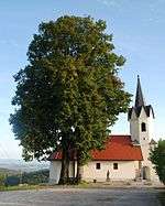
St. James the Greater Church in Pavla Vas
The local church is dedicated to Saint James (Slovene: sveti Jakob) and belongs to the Parish of Tržišče. It is a medieval building with a Romanesque nave that was restyled in the Baroque in the 17th century.[3]
References
- ↑ Statistical Office of the Republic of Slovenia
- ↑ Sevnica municipal site
- ↑ "EŠD 2616". Registry of Immovable Cultural Heritage (in Slovenian). Ministry of Culture of the Republic of Slovenia. Retrieved 17 October 2011.
External links
 Media related to Pavla Vas at Wikimedia Commons
- Pavla Vas at Geopedia

This article is issued from Wikipedia - version of the 1/14/2016. The text is available under the Creative Commons Attribution/Share Alike but additional terms may apply for the media files.