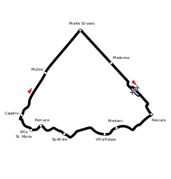
Pescara Circuit
 | |
| Location | Pescara, Italy |
|---|---|
| Major events |
Formula One Pescara Grand Prix Coppa Acerbo Targa Abruzzo |
| Length | 25.8 km (16.032 mi) |
| Lap record |
9:44.6 ( |
The Pescara Circuit was a 16.032 miles (25.8 km) road race course near Pescara, Italy. The staggering length was the longest of any open-wheel championship event.
The roads were both narrow and bumpy. Like many long circuits (such as the original Nürburgring and Spa-Francorchamps circuits) Pescara was extremely dangerous.
The long track travelled through a number of villages near Pescara, following a roughly triangular shape with its corners at the seaside municipality of Pescara, moving west to the inland municipality of Cappelle sul Tavo, then northeast to the seaside municipality of Montesilvano before returning to Pescara. The Pescara Circuit included two long straights between villages on the southwest-to-north and north-to-southeast legs, as well as demanding corners along the south leg. The highest point, at Spoltore, was 185 m above sea level.
The first race took place in 1924 and non-Championship Formula One races followed in the early 1950s, with one official Formula One World Championship event in 1957. The Pescara Grand Prix drew in excess of 200,000 spectators, and remains the longest circuit in terms of lap distance ever to stage a Formula One Grand Prix. But the circuit was feared even by Enzo Ferrari- who did not send his cars to this race out of fear for his drivers' safety.[1]
It was the first F1 circuit with an artificial chicane, built in 1934 on the start-finish straight to reduce speed in the pits.
The track's last race was a four-hour World Sportscar Championship race in 1961, won by Lorenzo Bandini and Giorgio Scarlatti. After that race the circuit was permanently retired as a racing venue as it was impossible for the organizers to guarantee the safety of drivers and spectators.
References
- ↑ "Six of the Best...F1 circuits". Patronise F1. 16 August 2009. Retrieved 13 July 2013.
External links
- Etracksonline page on Pescara circuit
- Approximate circuit layout on Google Maps
- Approximate circuit layout on Motopaner
Coordinates: 42°28′30″N 14°9′3″E / 42.47500°N 14.15083°E