Phitsanulok Airport
| Phitsanulok Airport ท่าอากาศยานพิษณุโลก | |||||||||||
|---|---|---|---|---|---|---|---|---|---|---|---|
 | |||||||||||
| IATA: PHS – ICAO: VTPP | |||||||||||
| Summary | |||||||||||
| Airport type | Public | ||||||||||
| Operator | Government | ||||||||||
| Serves | Phitsanulok, Thailand | ||||||||||
| Elevation AMSL | 154 ft / 47 m | ||||||||||
| Coordinates | 16°46′23″N 100°16′56″E / 16.77306°N 100.28222°ECoordinates: 16°46′23″N 100°16′56″E / 16.77306°N 100.28222°E | ||||||||||
| Map | |||||||||||
 PHS Location of airport in Thailand | |||||||||||
| Runways | |||||||||||
| |||||||||||
Phitsanulok Airport (Thai: ท่าอากาศยานพิษณุโลก) (IATA: PHS, ICAO: VTPP) is an airport serving Phitsanulok, a city in the Phitsanulok Province of Thailand. The airport is south of the city's downtown area.
Airlines and destinations
| Airlines | Destinations |
|---|---|
| Nok Air | Bangkok-Don Mueang |
| Kan Air | Chiang Mai |
| Thai AirAsia | Bangkok-Don Mueang [3] |
Miscellaneous
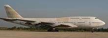
One of the two Orient Thai Boeing 747 at Phitsanulok Airport.
To the right and to the left of the tarmac are two decommissioned Boeing 747 jets from Orient Thai airline.
References
- ↑ Airport information for VTPP at World Aero Data. Data current as of October 2006.Source: DAFIF.
- ↑ Airport information for PHS at Great Circle Mapper. Source: DAFIF (effective October 2006).
- ↑ http://www.nationmultimedia.com/business/AirAsia-to-fly-Bangkok-Phitsanulok-twice-daily-30216619.html
External links
 Phitsanulok travel guide from Wikivoyage
- Phitsanulok Airport, Dept of Civil Aviation
- Current weather for VTPP at NOAA/NWS
- Accident history for PHS at Aviation Safety Network
- Airport information for VTPP at World Aero Data. Data current as of October 2006.
This article is issued from Wikipedia - version of the 11/27/2016. The text is available under the Creative Commons Attribution/Share Alike but additional terms may apply for the media files.