Pinhais
| Pinhais | |
|---|---|
|
Buildings at the boundary between Pinhais and Curitiba | |
|
Nickname(s): "Terra dos pinheirais" / "Morada da Gralha-Azul" (Land of the pine fields / Home of the Azure Jay) | |
 Location of Pinhais in Paraná state and Brazil | |
| Coordinates: 25°25′57″S 49°11′36″W / 25.43250°S 49.19333°WCoordinates: 25°25′57″S 49°11′36″W / 25.43250°S 49.19333°W | |
| Country |
|
| Region | South |
| State | Paraná |
| Founded | March 20, 1992 |
| Government | |
| • Mayor | Luiz Goularte Alves (PT) |
| Area | |
| • Total | 61.007 km2 (23.555 sq mi) |
| Elevation | 893 m (2,930 ft) |
| Population (2012) | |
| • Total | 119,379 |
| • Density | 2,000/km2 (5,100/sq mi) |
| [1] | |
| Time zone | UTC-3 (UTC-3) |
| • Summer (DST) | UTC-2 (UTC-2) |
| HDI (2000) | 0.815 – high[2] |
| Website | www.pinhais.pr.gov.br |

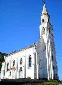
Our Lady of Good Hope Church
Pinhais is a municipality in Paraná state in Brazil. As of 2012, the population was 119,379. It was emancipated from the municipality of Piraquara in 1992 and is part of the metropolitan region of Curitiba. It is the smallest municipality in Paraná by area. In its territory lies the Autódromo Internacional de Curitiba.
Education
Private schools:
References
- ↑ "2012 Populational Estimate" (PDF). Censo Populacional 2012. Instituto Brasileiro de Geografia e Estatística (IBGE). July 2012. Retrieved September 9, 2012.
- ↑ - UNDP
- ↑ "Contact." Colégio Suíço-Brasileiro de Curitiba. Retrieved on April 25, 2016. "Street: Wanda dos Santos Mallmann, 537 Zip code: 83323-400 Pinhais (PR) - Brasil " - German, Portuguese
External links
| Wikimedia Commons has media related to Pinhais. |
This article is issued from Wikipedia - version of the 7/2/2016. The text is available under the Creative Commons Attribution/Share Alike but additional terms may apply for the media files.
