Pino sulla Sponda del Lago Maggiore
| Pino sulla Sponda del Lago Maggiore | |
|---|---|
| Comune | |
| Comune di Pino sulla Sponda del Lago Maggiore | |
.svg.png) | |
 Pino sulla Sponda del Lago Maggiore Location of Pino sulla Sponda del Lago Maggiore in Italy | |
| Coordinates: 46°6′6″N 8°44′23″E / 46.10167°N 8.73972°ECoordinates: 46°6′6″N 8°44′23″E / 46.10167°N 8.73972°E | |
| Country | Italy |
| Region | Lombardy |
| Province / Metropolitan city | Varese (VA) |
| Frazioni | Zenna, Monti di Pino, Alpe Cortiggia, Piano Volpera, Bersona, Mulinaccio, Alpe Tabia, Piano della Rogna, Alpe di Piero |
| Government | |
| • Mayor | Riccardo Zanini |
| Area | |
| • Total | 7.1 km2 (2.7 sq mi) |
| Elevation | 289 m (948 ft) |
| Population (Dec. 2004)[1] | |
| • Total | 251 |
| • Density | 35/km2 (92/sq mi) |
| Demonym(s) | Pinesi |
| Time zone | CET (UTC+1) |
| • Summer (DST) | CEST (UTC+2) |
| Postal code | 21010 |
| Dialing code | 0332 |
Pino sulla Sponda del Lago Maggiore is a village and comune (municipality) in the Province of Varese in the Italian region Lombardy, located about 110 km northwest of Milan and about 70 km northwest of Varese, on the border with Switzerland.
Pino sulla Sponda del Lago Maggiore as seen from the western side of the lake
View to the north, Pino sulla Sponda del Lago Maggiore and train station Pino-Tronzano
Pino sulla Sponda del Lago Maggiore borders the following municipalities: Brissago (Switzerland), Caviano (Switzerland), Gerra (Gambarogno) (Switzerland), Maccagno, Ronco sopra Ascona (Switzerland), San Nazzaro (Switzerland), Sant'Abbondio (Switzerland), Tronzano Lago Maggiore, Veddasca.
Pino sulla Sponda del Lago Maggiore is, along with San Valentino in Abruzzo Citeriore, the Italian comune with the longest name (30 letters).
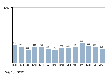
Demographic evolution

References
External links
| Wikimedia Commons has media related to Pino sulla Sponda del Lago Maggiore. |
This article is issued from Wikipedia - version of the 8/10/2016. The text is available under the Creative Commons Attribution/Share Alike but additional terms may apply for the media files.
