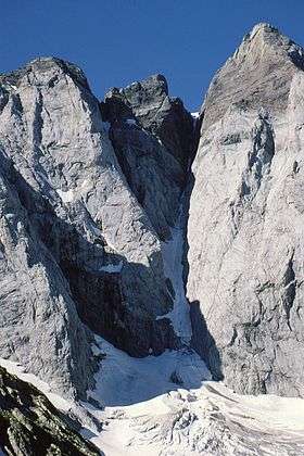
Pointe Chausenque
| Pointe Chausenque | |
|---|---|
 De gauche à droite : Pointe de Chausenque, Piton Carré, couloir de Gaube et Pique Longue du Vignemale | |
| Highest point | |
| Elevation | 3,204 m (10,512 ft) |
| Listing | List of Pyrenean three-thousanders |
| Coordinates | 42°46′25″N 0°08′30″E / 42.77361°N 0.14167°ECoordinates: 42°46′25″N 0°08′30″E / 42.77361°N 0.14167°E [1] |
| Geography | |
 Pointe Chausenque Location in the Pyrenees | |
| Location | Hautes-Pyrénées, France |
| Parent range | Massif du Vignemale (Pyrenees) |
| Climbing | |
| First ascent | June 30, 1822 by Vincent de Chausenque with a guide from Cauterets |
| Easiest route | From glacier d'Ossoue |
La Pointe Chausenque, culminating at 3,204 m is a summit in the Massif du Vignemale in the French Pyrenees.
Topography
Virtually as high as the glacier d'Ossoue to the south, it dominates from 600 m le glacier des Oulettes to the north.
It is the highest pyrenean summit located only in France, north of the French-Spanish border.
History
The first ascent was led out by Vincent de Chausenque and a guide from Cauterets on June 30, 1822. The summit was reached from the Petit Vignemale by the ridge linking both summits.
References
- ↑ Source : Géoportail
This article is issued from Wikipedia - version of the 4/14/2015. The text is available under the Creative Commons Attribution/Share Alike but additional terms may apply for the media files.