Quioveo
.jpg)
Map of the Gulf of Guinea, showing São Tomé, Príncipe, and Annobón.
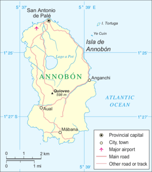
Map of Annobón showing the location of Quioveo on the island.
Quioveo is the extinct volcanic peak at the centre of the island of Annobón, Equatorial Guinea. It rises to a height of 598 metres. [1]
The island of Annobón is part of the Cameroon line of volcanoes, together with the islands of São Tomé Island, Príncipe, Bioko, and Mount Cameroon on the African mainland.
References
- ↑ "Profile on geonames.org", accessed May 24, 2011.
Coordinates: 1°26′13″S 5°37′59″E / 1.43694°S 5.63306°E
This article is issued from Wikipedia - version of the 7/5/2013. The text is available under the Creative Commons Attribution/Share Alike but additional terms may apply for the media files.