RAF Little Staughton
| RAF Little Staughton RAF Staughton Moor USAAF Station 127 | |||||||||||||||||||
|---|---|---|---|---|---|---|---|---|---|---|---|---|---|---|---|---|---|---|---|
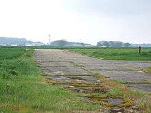
 Disused WW2 runway | |||||||||||||||||||
| IATA: none – ICAO: none | |||||||||||||||||||
| Summary | |||||||||||||||||||
| Airport type | Military | ||||||||||||||||||
| Owner | Air Ministry | ||||||||||||||||||
| Operator |
United States Army Air Forces Royal Air Force United States Air Force | ||||||||||||||||||
| Location | Little Staughton, Bedfordshire | ||||||||||||||||||
| Built | 1941 | ||||||||||||||||||
| In use | 1942-1947 | ||||||||||||||||||
| Elevation AMSL | 207 ft / 63 m | ||||||||||||||||||
| Coordinates | 52°14′40″N 000°21′42″W / 52.24444°N 0.36167°WCoordinates: 52°14′40″N 000°21′42″W / 52.24444°N 0.36167°W | ||||||||||||||||||
| Map | |||||||||||||||||||
 RAF Little Staughton Location in Cambridgeshire | |||||||||||||||||||
| Runways | |||||||||||||||||||
| |||||||||||||||||||

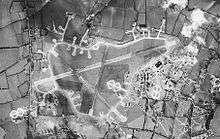
Aerial photograph of Little Staughton airfield looking north, the technical site and barrack sites are to the right, 10 February 1944.
Royal Air Force Station Little Staughton or more simply RAF Little Staughton is a former Royal Air Force station located 1.7 miles (2.7 km) south of Great Staughton, Cambridgeshire and 4.2 miles (6.8 km) west of St Neots, Cambridgeshire, England.
Station history
The airfield was first handed over to the United States Army Air Forces (USAAF) in 1942.[1]
RAF Little Staughton was returned to the Royal Air Force (RAF) on 1 March 1944.[1]
- No. 47 Group Communications Flight.[2]
- No. 48 Group Communications Flight.[2]
- No. 109 Squadron RAF from 2 April 1944 with the de Havilland Mosquito XVI before being disbanded on 30 April 1945.[3]
- No. 582 Squadron RAF formed at the airfield on 1 April 1944 with the Avro Lancaster Mks I and III before being disbanded on 10 September 1945.[4]
The airfield was placed into care and maintenance in 1945 and during the 1950s the United States Air Force extended the runway for use for Jet aircraft in emergency circumstances however in the late 1950s they moved out.[1]
See also
Current use
The site is mainly for farming with the hangars used for various uses.[2]
References
Citations
- 1 2 3 4 5 "Little Staughton". Royal Air Force. Retrieved 6 November 2012.
- 1 2 3 "Little Staughton II (Staughton Moor)". Airfields of Britain Conservation Trust. Retrieved 7 November 2012.
- ↑ Jefford 1988, p. 55.
- ↑ Jefford 1988, p. 97.
Bibliography
- Jefford MBE, Wg Cdr C G (1988). RAF Squadrons. A comprehensive record of the movement and equipment of all RAF squadrons and their antecedents since 1912. Shrewsbury: Airlife. ISBN 1-85310-053-6.
This article is issued from Wikipedia - version of the 8/14/2015. The text is available under the Creative Commons Attribution/Share Alike but additional terms may apply for the media files.
