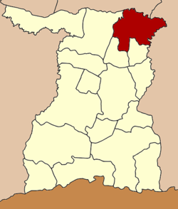
Rattanaburi District
| Rattanaburi รัตนบุรี | |
|---|---|
| Amphoe | |
 Amphoe location in Surin Province | |
| Coordinates: 15°19′13″N 103°51′25″E / 15.32028°N 103.85694°ECoordinates: 15°19′13″N 103°51′25″E / 15.32028°N 103.85694°E | |
| Country |
|
| Province | Surin |
| Area | |
| • Total | 202.8 km2 (78.3 sq mi) |
| Population (2005) | |
| • Total | 94,060 |
| • Density | 463.8/km2 (1,201/sq mi) |
| Time zone | THA (UTC+7) |
| Postal code | 32130 |
| Geocode | 3207 |
Rattanaburi (Thai: รัตนบุรี) is a district (Amphoe) in the northeastern part of Surin Province, northeastern Thailand.
History
Rattanaburi was a Mueang under Mueang Surin, which was converted into a district in the thesaphiban administrative reforms at the end of the 19th century.
Geography
Neighboring districts are (from the south clockwise) Non Narai, Sanom and Tha Tum of Surin Province, Suwannaphum and Phon Sai of Roi Et Province, and Rasi Salai, Bueng Bun, Pho Si Suwan and Mueang Chan of Sisaket Province.
Administration
The district is subdivided into 12 subdistricts (tambon), which are further subdivided into 163 villages (muban). Rattanaburi is a township (thesaban tambon) which covers parts of the tambon Rattanaburi and Phai. There are further 12 Tambon administrative organizations (TAO).
| No. | Name | Thai name | Villages | Inh. | |
|---|---|---|---|---|---|
| 1. | Rattanaburi | รัตนบุรี | 17 | 15,518 | |
| 2. | That | ธาตุ | 14 | 7,271 | |
| 3. | Kae | แก | 15 | 6,322 | |
| 4. | Don Raet | ดอนแรด | 16 | 9,760 | |
| 5. | Nong Bua Thong | หนองบัวทอง | 10 | 4,649 | |
| 6. | Nong Bua Ban | หนองบัวบาน | 15 | 10,999 | |
| 9. | Phai | ไผ่ | 14 | 9,573 | |
| 11. | Boet | เบิด | 17 | 7,702 | |
| 13. | Nam Khiao | น้ำเขียว | 13 | 5,704 | |
| 14. | Kut Kha Khim | กุดขาคีม | 11 | 5,912 | |
| 15. | Yang Sawang | ยางสว่าง | 11 | 4,508 | |
| 16. | Thap Yai | ทับใหญ่ | 10 | 6,142 |
Missing numbers are tambon which now form the district Non Narai.