Red Clay State Park
| Red Clay State Historic Park | |
|---|---|
|
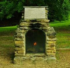
Eternal Flame of the Cherokee Nation | |
| Type | Tennessee State Park |
| Location | Bradley County, Tennessee |
| Area | 263 acres (1.06 km2) |
| Open |
year round |
|
Red Clay Council Ground | |
| Nearest city | Cleveland, Tennessee |
| Area | 150 acres (61 ha) |
| NRHP Reference # | 72001229[1] |
| Added to NRHP | September 14, 1972 |
Red Clay State Historic Park is a state park located in southern Bradley County, Tennessee. The park is also listed as an interpretive center along the Cherokee Trail of Tears. It encompasses 263 acres (1.06 km2) of land and is located just above the Tennessee-Georgia stateline.
The park was the site of the last seat of Cherokee national government before the 1838 enforcement of the Indian Removal Act of 1830 by the U.S. military, which resulted in most of the Cherokee people in the area being forced to emigrate West. Eleven general councils were held between 1832 and 1837.[2]
The James F. Corn Interpretive Center features exhibits about 18th and 19th century Cherokee culture, government, economy, recreation, religion and history. A series of stained glass windows depicts the forced removal of the Cherokee and subsequent Trail of Tears emigration. There is also a video about the Cherokee. Outside there is a replica of a Cherokee farmstead and a Council House.
Other nearby Cherokee points of interest are the cabin of Chief John Ross located in Rossville, Georgia[3] and the grave site of Nancy Ward in Benton, Tennessee.
References
- ↑ National Park Service (2010-07-09). "National Register Information System". National Register of Historic Places. National Park Service.
- ↑ Lois Osborne, "Red Clay State Historic Park," Tennessee Encyclopedia of History and Culture.
- ↑ Ross House, Roadsidegeorgia.com, 2003.
External links
| Wikimedia Commons has media related to Red Clay State Park. |
