Rimswell
| Rimswell | |
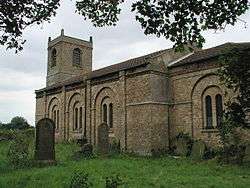 St Mary's Church |
|
 Rimswell |
|
| Population | 235 (2011 census)[1] |
|---|---|
| OS grid reference | TA312287 |
| – London | 155 mi (249 km) S |
| Civil parish | Rimswell |
| Unitary authority | East Riding of Yorkshire |
| Ceremonial county | East Riding of Yorkshire |
| Region | Yorkshire and the Humber |
| Country | England |
| Sovereign state | United Kingdom |
| Post town | WITHERNSEA |
| Postcode district | HU19 |
| Dialling code | 01964 |
| Police | Humberside |
| Fire | Humberside |
| Ambulance | Yorkshire |
| EU Parliament | Yorkshire and the Humber |
| UK Parliament | Beverley and Holderness |
Coordinates: 53°44′18″N 0°00′43″W / 53.738223°N 0.011959°W
Rimswell is a village and civil parish in the East Riding of Yorkshire, England, in an area known as Holderness. It is situated approximately 2 miles (3 km) north-west of Withernsea and it lies between the B1243 and B1362 roads.
The civil parish is formed by the village of Rimswell and the hamlet of Waxholme. According to the 2011 UK census, Rimswell parish had a population of 235,[1] an increase on the 2001 UK census figure of 198.[2]
The parish church of St Mary (now closed) is a Grade II listed building.[3]
The Prime Meridian passes just to the east of Rimswell.
In 1823 Rimswell was in the parish of Owthorne, a village since lost to coastal erosion. Rimswell inhabitants numbered 129, and occupations included ten farmers, some of whom were land owners, a grocer, and the landlord of the Dog and Duck public house. A carrier operated between the village and Hull on Tuesdays.[4][5]
References
- 1 2 "Key Figures for 2011 Census: Key Statistics: Area: Rimswell CP (Parish)". Neighbourhood Statistics. Office for National Statistics. Retrieved 6 February 2013.
- ↑ "2001 Census: Key Statistics: Parish Headcounts: Area: Rimswell CP (Parish)". Neighbourhood Statistics. Office for National Statistics. Retrieved 19 May 2008.
- ↑ Historic England. "Church of St Mary (1083462)". National Heritage List for England. Retrieved 6 February 2013.
- ↑ Baines, Edward; History, Directory & Gazetteer of the County of York (1823), p.582. ISBN 1230139141
- ↑ "Lost Villages; Owthorne and Withernsea - the Sisterkirkes" (pdf). Retrieved 23 May 2014.
- Gazetteer — A–Z of Towns Villages and Hamlets. East Riding of Yorkshire Council. 2006. p. 9.
External links
![]() Media related to Rimswell at Wikimedia Commons
Media related to Rimswell at Wikimedia Commons