Rock Island Trail State Park (Missouri)
| Rock Island Trail State Park | |
|---|---|
|
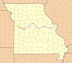
Location of the Rock Island Trail in red and the Katy Trail in blue | |
| Length | 47.5 mi (76.4 km) |
| Location | Missouri, United States |
| Trailheads | Windsor, Pleasant Hill |
| Use | Hiking, Cycling |
| Elevation | |
| Elevation change | negligible |
| Hiking details | |
| Trail difficulty | Easy |
| Season | All |
| Hazards |
Severe weather Poison ivy Snakes |
| Website | Rock Island Trail State Park |
Rock Island Trail State Park is a state park under construction in the U.S. state of Missouri that will be a 47-mile (76 km) rails to trails hiking and biking trail. Work on the trail should be completed by the end of 2016.[1] When opened the trail will provide residents of the Kansas City region direct trail access to the 240 mi (390 km) Katy Trail State Park, the longest rails to trails trail in the U.S. The Rock Island Trail uses abandoned right-of-way of the Chicago, Rock Island and Pacific Railroad between Pleasant Hill in Cass County and Windsor in Henry County where it meets the Katy Trail.
An additional 144 miles (232 km) of Rock Island right-of-way has been approved for rail banking by the Surface Transportation Board and will be added to the Rock Island Trail, extending it from Windsor to Beaufort. When completed the combined Rock Island and Katy trails will form a network of 450 miles (720 kilometres), though as of 2016 no timeline has been given for completion of the Beaufort extension.[2] [3]
Efforts are underway also to acquire 17.7 miles (28.5 km) of right-of-way to bring the trail from Pleasant Hill into the heart of Kansas City.[4]
References
- ↑ "Missouri on pace to complete 47.5-mile extension of Katy Trail from Windsor to Pleasant Hill, Gov. Nixon announces". Office of Missouri Governor Jay Nixon. 2015-09-17. Retrieved 2016-02-23.
- ↑ "Frequently Asked Questions about the Rock Island Corridor from Windsor to Beaufort" (PDF). Missouri Department of Natural Resources. Retrieved 2016-02-23.
- ↑ "Missouri's planned Rock Island Trail gets a federal boost". Kansas City Star. 2015-02-27. Retrieved 2016-02-23.
- ↑ Brent Hugh (2015-09-30). "Jackson County & KCATA announce partnership to acquire final piece of cross-state Rock Island-Katy Trail system". Missouri Bicycle and Pedestrian Federation. Retrieved 2016-02-26.
External links
- Rock Island Trail State Park Missouri Department of Natural Resources
- BikeRockIsland.com: maps, mileage, and other Rock Island Trail usage tools
Coordinates: 38°32′35″N 93°31′34″W / 38.543°N 93.526°W
