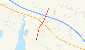
Massachusetts Route 136
| ||||
|---|---|---|---|---|
 | ||||
| Route information | ||||
| Maintained by MassDOT | ||||
| Length: | 1.85 mi[1] (2.98 km) | |||
| Existed: | 1933 – present | |||
| Major junctions | ||||
| South end: |
| |||
| North end: | Davis Street in Rehoboth | |||
| Location | ||||
| Counties: | Bristol | |||
| Highway system | ||||
| ||||
Route 136 is a short south–north state highway entirely in Swansea, Massachusetts that is a continuation of R.I. Route 136, connecting that road with Exit 2 of I-195 after crossing Route 6. Official descriptions state that the final 0.18 miles (0.29 km) of Route 136 continues north as Kingsley Way in Rehoboth ending at Davis Street, though aside from an "END 136" shield just before the intersection with Davis Street,[2] there is no other signage indicating this, either on Davis Street or on the off-ramp from I-195 West, which only indicate that Route 136 is to the left from that ramp. It is also missing one of the most certain signs of a continuation - one of the Bay State's ubiquitous white town signs at the Rehoboth town line.
Junction List
The entire route is in Bristol County.
| Location | mi | km | Destinations | Notes | |
|---|---|---|---|---|---|
| Swansea | 0.00 | 0.00 | Continuation into Rhode Island. | ||
| 1.0 | 1.6 | ||||
| 1.3 | 2.1 | Exit 2 on I-195. | |||
| Rehoboth | 1.85 | 2.98 | Davis Street | Northern terminus. | |
| 1.000 mi = 1.609 km; 1.000 km = 0.621 mi | |||||
References
- ↑ Executive Office of Transportation - Office of Transportation Planning Roads - June 2008
- ↑ "Street View". Google Maps. Google. Retrieved 8 October 2015.
