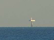
Royal Sovereign Lighthouse
 Royal Sovereign Lighthouse from Eastbourne | |
 East Sussex | |
| Location |
offshore Eastbourne East Sussex England |
|---|---|
| Coordinates | 50°43′24″N 0°26′08″E / 50.72333044°N 0.435498258°ECoordinates: 50°43′24″N 0°26′08″E / 50.72333044°N 0.435498258°E[1] |
| Year first constructed | 1875 (established lightship) |
| Year first lit | 1971 (current) |
| Automated | 1994 |
| Construction | concrete column |
| Tower shape | huge cylindrical column supporting the upper platform hosting the keeper's quarter, the helipad and the octagonal prism tower with balcony and lantern |
| Markings / pattern | white tower with a red band, white keeper's quarter |
| Height | 36 m (118 ft) |
| Focal height | 28 m (92 ft) |
| Current lens | biform tideland ML300 lanterns |
| Light source | solar power |
| Intensity | 3,976 candela |
| Range | 12 nmi (22 km) |
| Characteristic | Fl W 20s. |
| Fog signal | 2 blasts every 30s. |
| Admiralty number | A0843 |
| NGA number | 1144 |
| ARLHS number | ENG 257 |
| Managing agent |
Trinity House[2] [3] |
Royal Sovereign lighthouse at Eastbourne is a lighthouse marking the Royal Sovereign shoal. Its distinctive shape is easily recognised as it comprises a large platform supported by a single pillar rising out of the water.
In 1971, the lighthouse replaced a light vessel which protected the Royal Sovereign Shoal since 1875. Originally, the platform was manned, accommodation being contained in the 'cabin section'. The light was automated in 1994 and is controlled by a 475MHz radio link to Trinity House managed by Vodafone. As of 2006 it was still occasionally occupied.[4]
See also
References
- ↑ GPS coordinates of Royal Sovereign
- ↑ Royal Sovereign The Lighthouse Directory. University of North Carolina at Chapel Hill. Retrieved May 5, 2016
- ↑ Royal Sovereign Lighthouse Trnity House. Retrieved May 5, 2016
- ↑ http://www.telegraph.co.uk/property/3354249/A-beacon-for-man-and-buoy.html
External links
| Wikimedia Commons has media related to Royal Sovereign Lighthouse. |
This article is issued from Wikipedia - version of the 10/13/2016. The text is available under the Creative Commons Attribution/Share Alike but additional terms may apply for the media files.