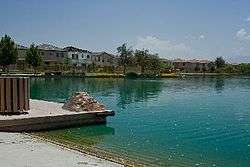
Sahuarita Lake
| Sahuarita Lake | |
|---|---|
|
December, 2007 | |
| Location |
Pima County, Arizona, United States |
| Coordinates | 31°58′30″N 110°58′4″W / 31.97500°N 110.96778°WCoordinates: 31°58′30″N 110°58′4″W / 31.97500°N 110.96778°W |
| Type | reservoir |
| Basin countries | United States |
| Surface area | 10 acres (4.0 ha) |
| Average depth | 7 ft (2.1 m) |
| Max. depth | 12 feet |
| Surface elevation | 2,715 ft (828 m) |
| Settlements | Sahuarita |

Sahuarita Lake Boat Ramp
Sahuarita Lake is a man made lake located 18 miles (29 km) south of downtown Tucson in Sahuarita, Arizona.
LOCATION Sahuarita Lake Park
15466 S Rancho Sahuarita Blvd[1]
PARK HOURS Sunrise to Sunset
SIZE 10 acres. Maximum depth 12 feet.
RULES Swimming, wading, glass containers, littering, cleaning of fish on premises and alcoholic beverages are prohibited. Boating permitted only between sunrise and sunset. Gas motors prohibited. Must have proper floatation devices on board. Animals must be restrained by a leash at all times. Other rules posted.
Fish species
- Rainbow Trout
- Largemouth Bass
- Sunfish
- Catfish (Channel)
External links
- Arizona Fishing Locations Map
- Arizona Boating Locations Facilities Map
- Video of Sahuarita Lake, Arizona
References
- ↑ Department, Arizona Game and Fish. "Arizona Game & Fish Department - Tucson". www.azgfd.com. Retrieved 2016-06-22.
- Arizona Game & Fish Department https://www.azgfd.com/fishing/community/tucson/sahuarita/
- Arizona Fishin' Holes, Phoenix, AZ: Arizona Game and Fish Department, 2007
|first1=missing|last1=in Authors list (help)
This article is issued from Wikipedia - version of the 8/16/2016. The text is available under the Creative Commons Attribution/Share Alike but additional terms may apply for the media files.