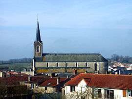
Saint-Germain-sur-Moine
| Saint-Germain-sur-Moine | |
|---|---|
 | |
 Saint-Germain-sur-Moine | |
|
Location within Pays de la Loire region  Saint-Germain-sur-Moine | |
| Coordinates: 47°07′07″N 1°07′18″W / 47.1186°N 1.1217°WCoordinates: 47°07′07″N 1°07′18″W / 47.1186°N 1.1217°W | |
| Country | France |
| Region | Pays de la Loire |
| Department | Maine-et-Loire |
| Arrondissement | Cholet |
| Canton | Saint-Macaire-en-Mauges |
| Area1 | 26.79 km2 (10.34 sq mi) |
| Population (2012)2 | 2,886 |
| • Density | 110/km2 (280/sq mi) |
| Time zone | CET (UTC+1) |
| • Summer (DST) | CEST (UTC+2) |
| INSEE/Postal code | 49285 / 49230 |
|
1 French Land Register data, which excludes lakes, ponds, glaciers > 1 km² (0.386 sq mi or 247 acres) and river estuaries. 2 Population without double counting: residents of multiple communes (e.g., students and military personnel) only counted once. | |
Saint-Germain-sur-Moine is a former commune in the Maine-et-Loire department in western France.
Geography
Saint-Germain-sur-Moine is located about 75 meters above sea level and is adjacent to the municipalities of Montfaucon-Montigné and Tillieres. The largest town near Saint-Germain-sur-Moine is the town of Cholet, situated 20 km south-east. The river Moine is the main river that runs through the town of Saint-Germain-sur-Moine.
History
On 15 December 2015, Le Longeron, Montfaucon-Montigné, La Renaudière, Roussay, Saint-André-de-la-Marche, Saint-Crespin-sur-Moine, Saint-Germain-sur-Moine, Saint-Macaire-en-Mauges, Tillières and Torfou merged becoming one commune called Sèvremoine.
Twinned towns
See also
References
External links
| Wikimedia Commons has media related to Saint-Germain-sur-Moine. |