Sancton
| Sancton | |
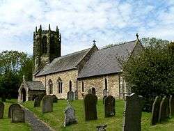 All Saint's Church, Sancton |
|
 Sancton |
|
| Population | 286 (2011 census)[1] |
|---|---|
| OS grid reference | SE901392 |
| Civil parish | Sancton |
| Unitary authority | East Riding of Yorkshire |
| Ceremonial county | East Riding of Yorkshire |
| Region | Yorkshire and the Humber |
| Country | England |
| Sovereign state | United Kingdom |
| Post town | YORK |
| Postcode district | YO43 |
| Dialling code | 01430 |
| Police | Humberside |
| Fire | Humberside |
| Ambulance | Yorkshire |
| EU Parliament | Yorkshire and the Humber |
| UK Parliament | East Yorkshire |
Coordinates: 53°50′31″N 0°37′54″W / 53.841984°N 0.631691°W
Sancton is a village and civil parish in the East Riding of Yorkshire, England. It is situated approximately 2 miles (3.2 km) south-east of the market town of Market Weighton on the A1034 road.
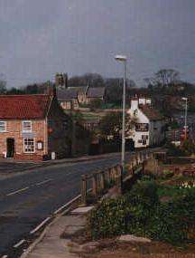
A1034 at Sancton
The civil parish is formed by the village of Sancton and the hamlet of Houghton. According to the 2011 UK census, Sancton parish had a population of 286,[1] a reduction of one on the 2001 UK census figure.[2]
The church dedicated to All Saints was designated a Grade II* listed building in 1967 and is now recorded in the National Heritage List for England, maintained by Historic England.[3]
Places of interest
For places of interest in Sancton, see Market Weighton and North Newbald.
References
- 1 2 "Key Figures for 2011 Census: Key Statistics: Area: Sancton CP (Parish)". Neighbourhood Statistics. Office for National Statistics. Retrieved 6 February 2013.
- ↑ "2001 Census: Key Statistics: Parish Headcounts: Area: Sancton CP (Parish)". Neighbourhood Statistics. Office for National Statistics. Retrieved 20 May 2008.
- ↑ Historic England. "Church of All Saints (1084105)". National Heritage List for England. Retrieved 16 August 2013.
- Gazetteer — A–Z of Towns Villages and Hamlets. East Riding of Yorkshire Council. 2006. p. 10.
External links
| Wikimedia Commons has media related to Sancton. |
- Sancton in the Domesday Book
This article is issued from Wikipedia - version of the 1/24/2016. The text is available under the Creative Commons Attribution/Share Alike but additional terms may apply for the media files.