Sauble Falls Provincial Park
| Sauble Falls Provincial Park | |
|---|---|
|
IUCN category II (national park) | |
 | |
 Location of the park in Ontario | |
| Location | Bruce County, Ontario, Canada |
| Nearest city | Sauble Beach |
| Coordinates | 44°40′32″N 81°15′24″W / 44.67556°N 81.25667°WCoordinates: 44°40′32″N 81°15′24″W / 44.67556°N 81.25667°W[1] |
| Area | 20 hectares (49 acres)[2] |
| Established | 1957 |
| Governing body | Ontario Parks |
| http://www.ontarioparks.com/english/saub.html | |
Sauble Falls Provincial Park is located in the community of Sauble Falls, town of South Bruce Peninsula, Bruce County in southwestern Ontario, Canada. It is in the lower drainage basin of the Sauble River, which flows into Lake Huron. The campground consists of two sections divided by County Road 13. The West section of the site is a quiet zone (no radios allowed). Group camping is available in the east section. Many sites along the east portion of the park back up against the Sauble River. The park is also the downstream terminus of the Rankin River canoe route.[2]
History
Sauble Falls Provincial Park opened in 1957 after lands were acquired from Ontario Hydro and from other owners.[3]
Nearby attractions
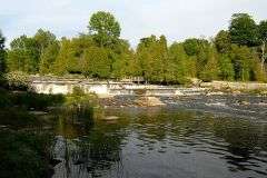
The main summer attractions of the area consist of the Sauble Falls and Sauble Beach. The river meanders around the east section of the park and flows down under the highway to the falls. The majority of the falls are actually rapids to which many people take day trips to play in. There is a section in which people jump from a drop off into a pool in the river. Also in certain years it is possible to slide down the falls if water levels are high enough. The other main summer attraction is Sauble Beach, a fresh water beach at least 12 kilometres (7 mi) long.[4]
References
- ↑ "Sauble Falls Provincial Park". Geographical Names Data Base. Natural Resources Canada. Retrieved 2011-07-03.
- 1 2 "Sauble Falls". Ontario Parks. 2011-06-17. Retrieved 2011-07-03.
- ↑ http://www.ghosttownpix.com/ontario/intros/sauble.html
- ↑ "Town of Sauble Beach". Explore the Bruce. Bruce County. Retrieved 2011-07-03.
