Sha'ar HaAmakim
| Sha'ar HaAmakim | |
|---|---|
|
Sha'ar HaAmakim in 2008 | |
 Sha'ar HaAmakim | |
| Coordinates: 32°43′22.79″N 35°6′47.88″E / 32.7229972°N 35.1133000°ECoordinates: 32°43′22.79″N 35°6′47.88″E / 32.7229972°N 35.1133000°E | |
| Grid position | 160/236 PAL |
| District | Haifa |
| Council | Zevulun Regional Council |
| Affiliation | Kibbutz Movement |
| Founded | 1935 |
| Founded by | Romanian and Yugoslavian immigrants |
| Population (2015)[1] | 687 |
| Website | www.s-h.org.il |
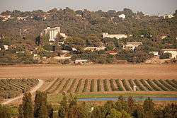
Sha'ar HaAmakim (Hebrew: שַׁעַר הַעֲמָקִים, lit. Gate of the Valleys) is a kibbutz in northern Israel associated with the Hashomer Hatzair movement founded in 1935. Located near Kiryat Tiv'on, it falls under the jurisdiction of Zevulun Regional Council. In 2015 it had a population of 687.
History
Antiquity
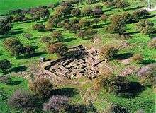
Human habitation in the area dates at least as far back as the Hellenistic period.[2]
Crusader era
In 1283, during the hudna ("truce") between the Crusaders based in Acre and the Mamluk sultan al-Mansur Qalawun, this location was named el Harathiyah and was described as part of the domain of the Crusaders.[3]
Ottoman era
During the Ottoman era, a Muslim village at the site was called el Hâritheh.[4] The village appeared as El Harti on the map of Pierre Jacotin compiled in 1799.[5] In 1859, the population was recorded as 120 with tillable land of 12 feddans.[6] In 1875, Victor Guérin reported about 40 houses.[7] In 1882, the Palestine Exploration Fund's Survey of Western Palestine described it as an adobe hamlet.[6]
British Mandate era
In 1925 a Zionist organisation purchased 50 feddans in Hartieh from the Sursock family of Beirut. At the time, there were 60 families living there.[8] From 1931, and lasting several years, the Jewish Agency struggled to evict the Arab tenant farmers from Hartiya.[9][10][11] According to Avneri, Hartiya land was to become Sha'ar HaAmakim.[9] According to the Department of Statistics, however, Sha'ar HaAmakim had previously been part of Sheikh Bureik.[12][13]
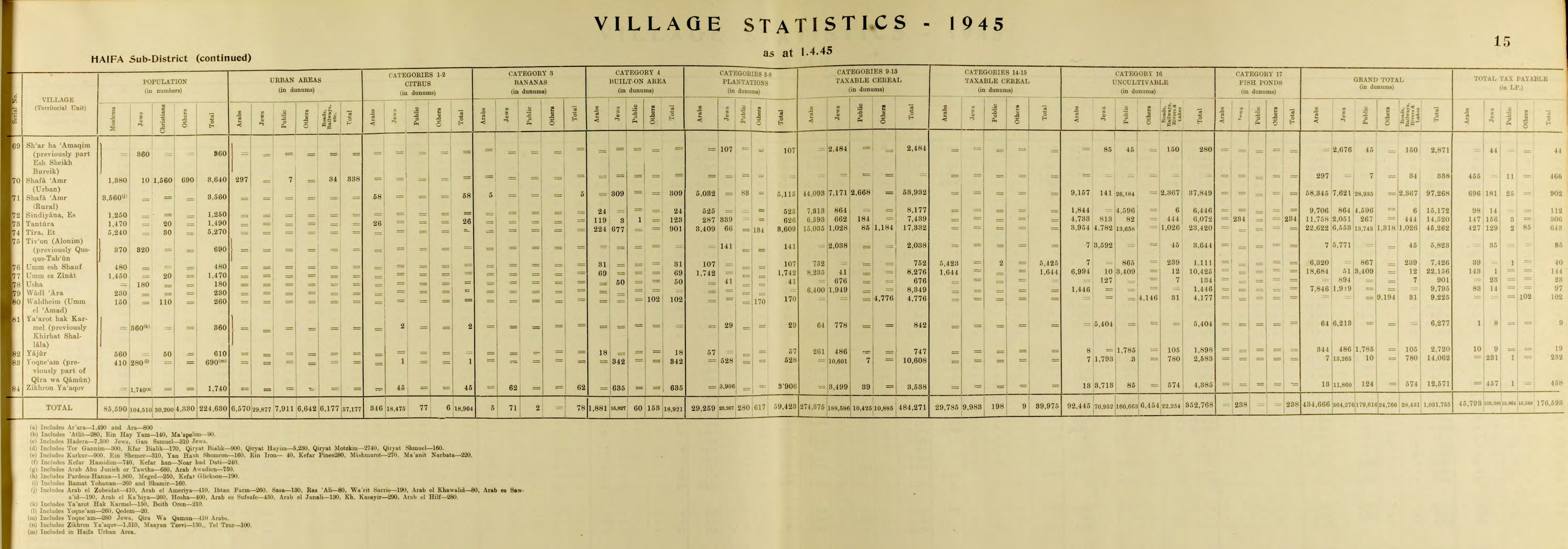
Kibbutz Sha'ar HaAmakim was founded in 1935 by immigrants from Romania and Yugoslavia. Its name was derived from the nearby confluence of the Jezreel and Zevulun valleys.[14] By 1945 it had a population of 360, all Jews.[12][13]
State of Israel
Sha'ar HaAmakim hosted volunteers from around the world, including France and the United States, who worked at the kibbutz and participated in cultural exchanges.[15] In the 1960s, there were up to 100 volunteers each year.[16] Bernie Sanders, who later became a U.S. Senator, worked at the kibbutz for several months in 1963.[17][18]
Economy
According to a 2016 report, the kibbutz derives most of its income from its solar water heater factory. It also makes money from agriculture, including dairy farming.[15] For over five decades, the kibbutz has produced and processed sunflower seeds which it markets under its name both in Israel and for export.[19] It also has a fish pond and orchards producing apples, peaches, and pears.[16]
References
- ↑ "List of localities, in Alphabetical order" (PDF). Israel Central Bureau of Statistics. Retrieved 16 October 2016.
- ↑ Segal, Arthur; Młynarczyk, Jolanta; Burdajewicz, Mariusz; Bar-Oz, Guy (2009). Excavations of the Hellenistic site in Kibbutz Sha'ar-Ha'Amakim. Haifa: Zinman Institute of Archaeology, University of Haifa. ISBN 9789659041879.
- ↑ Barag, 1979, p. 204
- ↑ ”the ploughed land”, Palmer, 1881, p. 109
- ↑ Karmon, 1960, p. 163
- 1 2 Conder and Kitchener, 1881, SWP I, p. 270
- ↑ Guérin, 1880, pp. 399-400
- ↑ List of villages sold by Sursocks and their partners to the Zionists since British occupation of Palestine Evidence to the Shaw Commission, 1930
- 1 2 Avneri, 1984, pp. 156-7
- ↑ 26 February 1935, House of Commons
- ↑ Bernie Sanders Stint at 'Stalinist' Kibbutz Draws Red-Baiting From Right, Nathan Guttman, February 5, 2016 The Forward
- 1 2 Department of Statistics, 1945, p. 15
- 1 2 Government of Palestine, Department of Statistics. Village Statistics, April, 1945. Quoted in Hadawi, 1970, p. 49
- ↑ History Sha'ar HaAmakim Seeds
- 1 2 Erlanger, Steven (February 5, 2016). "Bernie Sanders's Kibbutz Found. Surprise: It's Socialist.". The New York Times. Retrieved February 6, 2016.
- 1 2 Sales, Ben (February 8, 2016). "50 years on, Bernie Sanders still champions values of his Israeli kibbutz". Jewish Telegraphic Agency. Retrieved February 8, 2016.
- ↑ Aderet, Ofer (4 February 2016). "Mystery Solved? Haaretz Archive Reveals Which Kibbutz Bernie Sanders Volunteered On". Haaretz. Retrieved 5 February 2016.
- ↑ Sales, Ben (February 8, 2016). "50 years on, Bernie Sanders still champions values of his Israeli kibbutz". Jewish Telegraphic Agency. Retrieved February 8, 2016.
- ↑ "Shaar Haamakim Seeds". Sha'ar Ha'amakim Seeds, Ltd. Retrieved February 6, 2016.
Bibliography
- Avneri, Arieh L. (1984). The Claim of Dispossession: Jewish Land-settlement and the Arabs, 1878-1948. Transaction Publishers. ISBN 0-87855-964-7.
- Barag, Dan (1979). "A new source concerning the ultimate borders of the Latin Kingdom of Jerusalem". Israel Exploration Journal. 29: 197–217.
- Barron, J. B., ed. (1923). Palestine: Report and General Abstracts of the Census of 1922. Government of Palestine.
- Conder, Claude Reignier; Kitchener, H. H. (1882). The Survey of Western Palestine: Memoirs of the Topography, Orography, Hydrography, and Archaeology. 2. London: Committee of the Palestine Exploration Fund.
- Department of Statistics (1945). Village Statistics, April, 1945. Government of Palestine.
- Guérin, Victor (1880). Description Géographique Historique et Archéologique de la Palestine (in French). 3: Galilee, pt. 1. Paris: L'Imprimerie Nationale.
- Hadawi, Sami (1970). Village Statistics of 1945: A Classification of Land and Area ownership in Palestine. Palestine Liberation Organization Research Center.
- Karmon, Y. (1960). "An Analysis of Jacotin's Map of Palestine" (PDF). Israel Exploration Journal. 10 (3,4): 155–173; 244–253.
- Mills, E., ed. (1932). Census of Palestine 1931. Population of Villages, Towns and Administrative Areas. Jerusalem: Government of Palestine.
- Palmer, E. H. (1881). The Survey of Western Palestine: Arabic and English Name Lists Collected During the Survey by Lieutenants Conder and Kitchener, R. E. Transliterated and Explained by E.H. Palmer. Committee of the Palestine Exploration Fund.
External links
| Wikimedia Commons has media related to Shaar Haamkim. |
- Kibbutz website
- Survey of Western Palestine, Map 5: IAA, Wikimedia commons