Shek O
| Shek O | |||||||||||
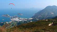
 Shek O as viewed from Dragon's Back | |||||||||||
| Chinese | 石澳 | ||||||||||
|---|---|---|---|---|---|---|---|---|---|---|---|
| Literal meaning | rocky bay | ||||||||||
| |||||||||||
Shek O is a beachside village located on the south-eastern part of Hong Kong Island, in Hong Kong. Administratively, it is part of Southern District. The scenery of Shek O is the setting of numerous Cantopop music videos.The Hong Kong director Stephen Chow's famous film "King of Comedy" (Chinese: 喜劇之王) was also shooting at Shek O.[1]
Geography
The name "Shek O" literally means the "rocky bay". The entire area is a peninsula on the southern coast of the Hong Kong Island, facing the South China Sea. Shek O is surrounded by Shek O Country Park, Big Wave Bay and Cape D'Aguilar.
Shek O Village
Shek O Village (石澳村) has a history of some 200 years.[2] It was established by fishermen of the Chan, Yip, Li and Lau clans.[3] In 1841, Shek O Village, together with Hok Tsui Village (鶴咀村) and Big Wave Village (大浪灣村), had a population of around 200. The Tin Hau Temple in Shek O Village was built in 1891.[2] Its management has been delegated by the Chinese Temples Committee to the Shek O Residents Association.[4] It is a Grade III historic building.[5]
Outdoor activities


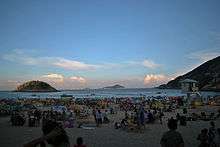
Shek O Beach is a sandy public beach at Shek O.[6] The water quality is fair and is gazetted Grade 2. It is a popular weekend and holiday destination, offering a public barbecue area and many restaurants. The rocky cliffs provide an excellent place for sports climbing.
Around one mile north of Shek O beach, after passing the Shek O Country Club, is Big Wave Bay. As its name suggests, big waves roll on to the beach, propelled by the wind, making it a popular destination for surfers. Wind surfers can be found in the sea off Big Wave Bay and Shek O beaches. The Dragon's Back above Shek O is home to Hong Kong Island's only paragliding site. Paragliders can be seen riding the lift and landing at the nearby Rocky Bay. Big Wave Bay Beach is also the site of prehistoric rock carving similar to those found on Cheung Chau Island.
Both beaches have basic bars and restaurants, and equipment hire, such as body boards and lilos. In addition, Shek O Beach has a small golf course.
Due to the isolated location of Shek O, the environment near the beach remains rustic and quiet, which is one of the area's main attractions.
The Shek O Country Club (石澳鄉村俱樂部) is built around a par 65 private golf course. Its history goes back to 1919. The construction of the Clubhouse was completed in 1925.[7]
Drownings
Shek O Beach has been noted as generally suffering from the highest drowning rate among Hong Kong's beaches, although this is not reflected in official statistics as the LCSD only records incidents which occur while lifeguards are on duty. Residents estimated nine drowning deaths at the beach in 2011, and seven in 2012, figures which were not disputed by the Leisure and Cultural Services Department (LCSD).[8] The high rate of accidents at the beach has been attributed to its high patronage, usually strong waves, the steep underwater slope of the beach, swimmer inexperience and poor public awareness of water safety principles.[8]
Transportation

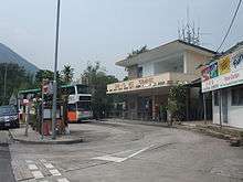
Shek O is served by Shek O Road, which connects Tai Tam Road to Stanley and Chai Wan. There is one public transport link toward Shek O Beach: bus route 9 from Shau Kei Wan. There is limited parking near the beach. It is also served by red minibuses.
References
- ↑ "随光逐影浪香港之石澳:《喜剧之王》". 豆瓣. Retrieved 2016-10-07.
- 1 2 Brief Information on No Grade Items. Item #1215
- ↑ Brief Information on Proposed Grade 3 Items. Item #878
- ↑ Chinese Temples Committee: Delegated Temples
- ↑ Antiquities and Monuments Office: List of the Historic Buildings in Building Assessment
- ↑ Leisure and Cultural Services Department: Shek O Beach
- ↑ Brief Information on Proposed Grade 3 Items. Item #928
- 1 2 Lanyon, Charley (25 June 2013). "Drownings at Shek O beach go unrecorded". South China Morning Post. Retrieved 1 August 2014.
External links
| Wikimedia Commons has media related to Shek O. |
Coordinates: 22°13′50″N 114°15′07″E / 22.23056°N 114.25194°E